
HASTE: A Platform for Rapid Post-Disaster Building Damage Assessment
Source: arXiv:2607.11838 · Published 2026-07-13 · By Caleb Robinson, Anthony Ortiz, Simone Fobi Nsutezo, Cameron Birge, Meygha Machado, Marcelo Duarte et al.
TL;DR
HASTE addresses a critical challenge in post-disaster rapid response: producing accurate building-level damage assessments within hours of a disaster using only post-event satellite imagery. Traditional supervised models rely on matched pre- and post-event imagery and extensive labeled datasets from similar past disasters, which are often unavailable or mismatched in real emergency scenarios. HASTE provides a no-code web platform empowering non-ML experts to generate per-building damage maps quickly through two complementary methods: (1) a per-scene semantic segmentation model trained on limited hand-labeled polygons over the post-disaster scene, and (2) a lightweight in-browser logistic regression classifier trained on pretrained vision-model embeddings pooled over building footprints, requiring only a handful of labeled buildings.
This platform design enables iterative human-in-the-loop workflows where analysts rapidly label and refine damage predictions with low latency, trading off between more detailed pixel-level segmentation (Method 1) and faster footprint-level classification (Method 2). Preliminary experiments on the xBD dataset show that embedding-based damage classifiers using only post-disaster imagery can match or exceed the performance of fully supervised fine-tuned networks, but with approximately twenty times fewer labeled examples. Since 2023, HASTE has supported over 30 real-world disaster responses (earthquakes, hurricanes, wildfires, etc.), delivering timely damage maps to humanitarian partners within hours to days. The study closes with promising future directions around vision-language models, active learning integration, and expanding damage assessment to roads and infrastructure beyond buildings.
Key findings
- Pretrained vision model embeddings pooled over building footprints separate damaged from intact buildings using only post-disaster imagery, achieving up to 0.92 macro ROC-AUC on xBD with 50% labeled data.
- Embedding-based logistic regression classifiers trained on as little as 1% labeled buildings per disaster reach a macro ROC-AUC of 0.84, outperforming a fully supervised fine-tuned ResNet-50 baseline which reached 0.77 with the same labels.
- The interactive embedding method enables re-training and re-scoring in the browser in seconds, supporting rapid analyst iteration vs. Method 1 segmentation taking 1-2 hours per retrain.
- The segmentation method with U-Net trained per-scene on sparse polygon labels can complete a training-review cycle in roughly 1-2 hours in operational deployment.
- HASTE has supported 31 disaster responses since 2023, delivering results within hours to days, with validation reports estimating precision and recall up to approximately 97% and 99% respectively in some cases.
- Damage maps tend to be conservative and have high specificity but lower sensitivity due to limitations like missing rubble outside footprint outlines.
- Cloud cover can occlude a significant fraction of footprints (e.g. 41% footprints obscured in Hurricane Melissa response), impacting assessable buildings.
- Pooling statistics over footprint tokens concatenating min, max, mean, and stddev improved damage classification accuracy compared to simpler pooling.
Threat model
The adversary is implicitly the uncertainty and lack of labeled data in rapid disaster response scenarios. Models cannot rely on pre-event imagery or extensive labeled datasets for new disasters, and must function under cloud cover, occlusion, and misalignment. The system assumes the analyst is honest and labels correctly; adversarial manipulation or spoofing scenarios are not considered.
Methodology — deep read
Threat Model & Assumptions: The target user is a disaster-response analyst without ML expertise who has access only to post-disaster satellite imagery and existing building footprint polygons, but not necessarily matched pre-event imagery. The model assumes limited labeled data (a handful of buildings labeled per scene) and no strong pre-trained damage classifier adapted to the event.
Data: The system uses post-disaster optical satellite imagery mosaicked into cloud-optimized GeoTIFF tiles and building footprints from open sources such as Microsoft and Overture Maps datasets. For evaluation, the publicly available xBD dataset is used, which contains >850,000 labeled buildings on a 4-class damage scale from 19 disaster events, with the scale collapsed to binary damaged vs intact for experiments. Data splits are by disaster scene, so testing buildings are not seen during training.
Architecture / Algorithms: Method 1 trains a U-Net semantic segmentation model with a ResNeXt-50 encoder pretrained on ImageNet on a single post-disaster scene. The analyst hand-labels polygons (intact, damaged, background) sparsely on the post-disaster imagery. Labels are rasterized into masks with unlabeled pixels ignored. Training batches sample tiles with sufficient labeled pixels. The model predicts pixel-level damage maps, then damage fractions per building footprint are computed by overlay. Method 2 extracts frozen pretrained vision model embeddings per pixel (patch tokens) pooled over each footprint via masked statistics (min, max, mean, std). Backbones used include random convolution features (MOSAIKS) and self-supervised ViT models (DINOv2, DINOv3). The analyst labels a few buildings by clicking. A lightweight logistic regression classifier with L2 regularization is trained in-browser on these footprint embeddings using gradient descent. This fits and scores the whole scene in seconds, enabling rapid interactive labeling.
Training Regime: Method 1 trains for a limited number of epochs per scene on GPUs using TorchGeo trainers with cross-entropy loss, augmented with a penalty term for coarse undamaged regions if marked. Method 2 trains logistic regression with regularization λ=0.01 in the browser using gradient descent, starting once at least 3 labels across 2 classes are provided.
Evaluation: Metrics include ROC-AUC (macro averaged across disasters), precision, recall, and average precision (AP). For operational validation, random validation samples of buildings are labeled by expert visual interpretation of the imagery to produce confusion matrices, precision-recall curves, and confidence intervals on damage counts. Evaluation is done per disaster with held-out test scenes.
Reproducibility: HASTE is open source (https://github.com/microsoft/haste) including model code and platform. The xBD dataset used in experiments is public, but operational imagery and footprints vary. Full end-to-end deployment system and GPU batch infrastructure described. The platform supports repeatable retraining and scoring workflows.
Example Workflow: An analyst uploads post-disaster imagery and selects building footprints. For Method 2, they label a dozen buildings as damaged or intact by clicking in the browser. The logistic regression retrains and recolors damage predictions for all footprints in seconds, letting the analyst iteratively revise labels. Damage probabilities per building are exported and summarized with a validation report containing metrics and uncertainty bounds. This happens without writing code or waiting hours for training.
The methodology combines human-in-the-loop rapid labeling with either pixel-level segmentation or embedding-based classification to overcome the lack of matched pre-event imagery or large labeled datasets for new disasters.
Technical innovations
- Introduction of a no-code web platform that allows non-ML experts to produce building damage maps quickly using only post-disaster imagery.
- Two complementary damage assessment methods: a per-scene semantic segmentation trained on limited new labels, and an embedding-based logistic regression trained interactively in-browser with minimal labeling.
- Pooling pretrained vision model embeddings over building footprints to enable rapid logistic regression classification without GPU training.
- Interactive in-browser retraining and scoring of the classifier within seconds to support iterative analyst labeling.
- Joint use of coarse undamaged region constraints in segmentation training loss as a regularizer to reduce false positives.
Datasets
- xBD — 850,000+ building polygons — public, contains pre- and post-event imagery with 4-level damage labels
- Microsoft building footprints — large scale building footprint vector dataset — open source
- Overture Maps footprints — open building footprint dataset — open source
Baselines vs proposed
- ResNet-50 fine-tuned on post-event crops (fully supervised): macro ROC-AUC = 0.77 at 1% labels, 0.88 at 100% labels
- DINOv3 ViT-L/16 embedding + logistic regression (HASTE Method 2): macro ROC-AUC = 0.84 at 1% labels, 0.92 at 50% labels
- MOSAIKS random convolution features + logistic regression: macro ROC-AUC = 0.70 at 1% labels, 0.84 at 50% labels
- Rolling Fork 2023 response per-scene segmentation model: 0.86 precision, 0.80 recall against field ground truth in under 2 hours
- Maui 2023 wildfire response: ~97% accuracy, 99% recall, and 96% precision by visual validation on damage labels
- Hurricane Melissa Jamaica response (Method 1): 96% recall, 82% precision (Black River); 86% recall, 71% precision (Montego Bay) per expert validation
Figures from the paper
Figures are reproduced from the source paper for academic discussion. Original copyright: the paper authors. See arXiv:2607.11838.
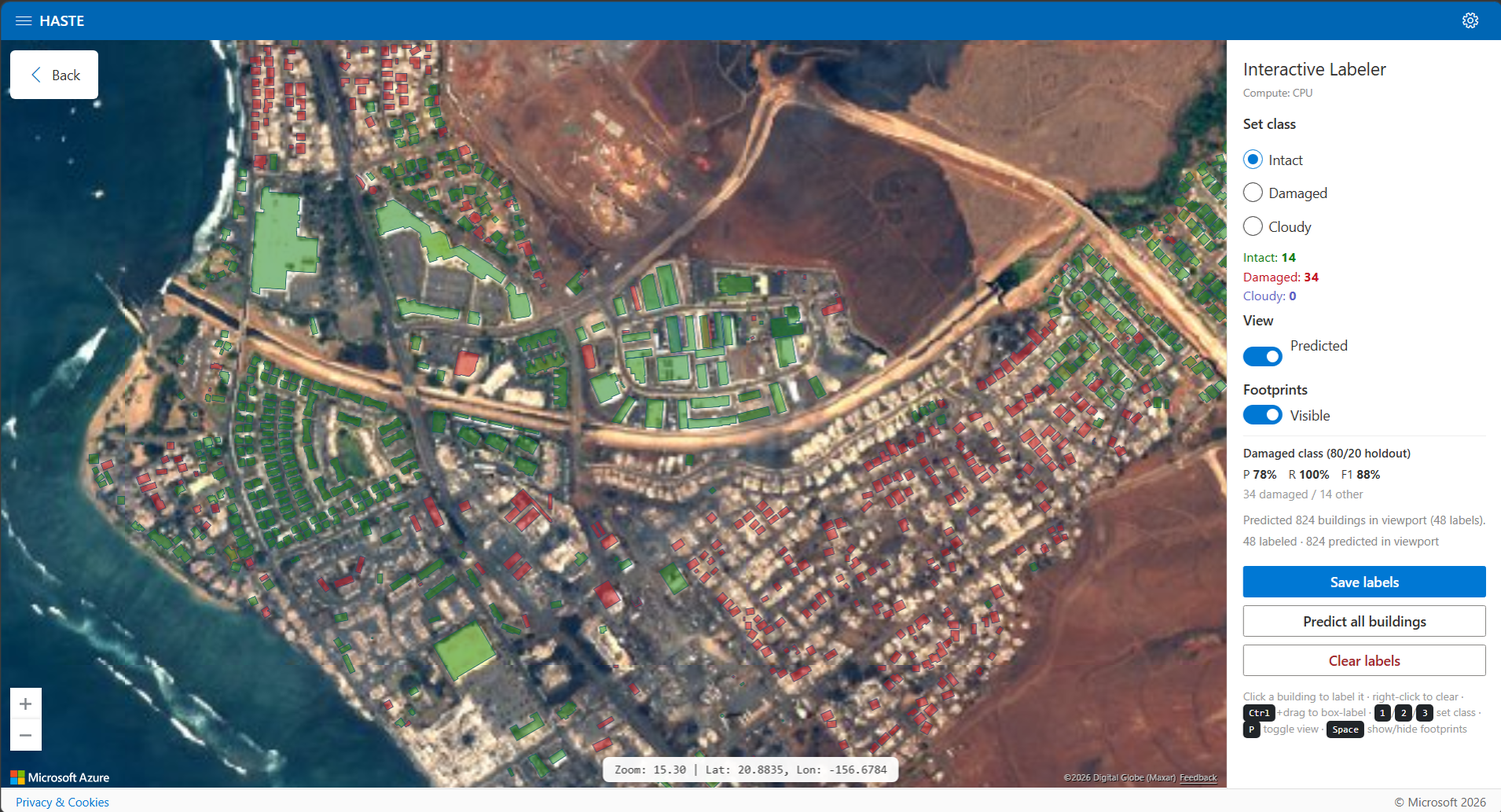
Fig 1: HASTE in use. Top, the interactive labeler over the 2023 Lahaina wildfire scene: the analyst has labeled 48 buildings,
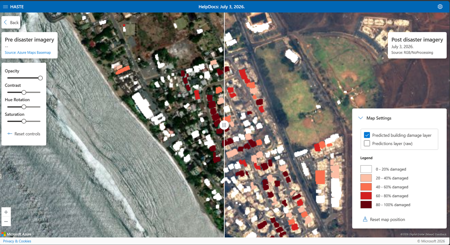
Fig 2: shows the main pieces. A React single-page application provides project
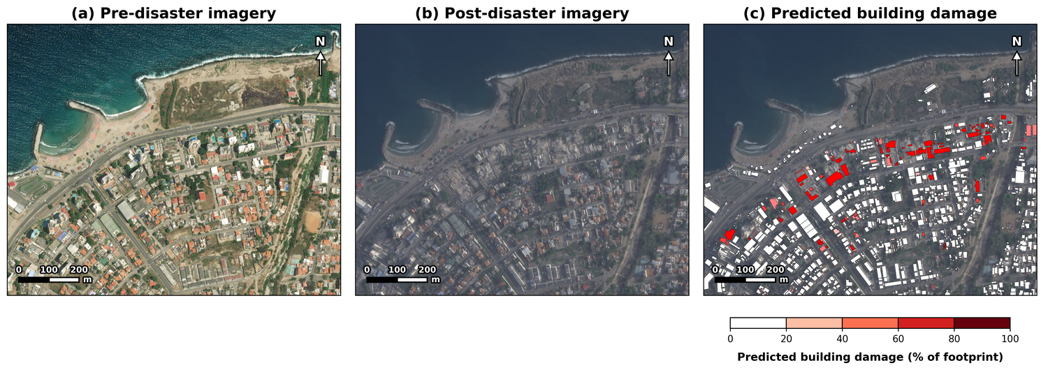
Fig 4: HASTE rapid building-damage assessment across two disaster responses. Each row shows, from left to right: (a)
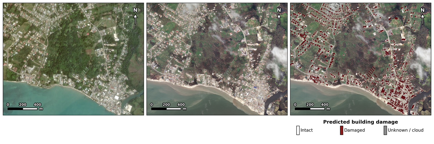
Fig 5: The per-scene workflow adapts beyond building damage. Left, flood extent and damaged infrastructure mapped
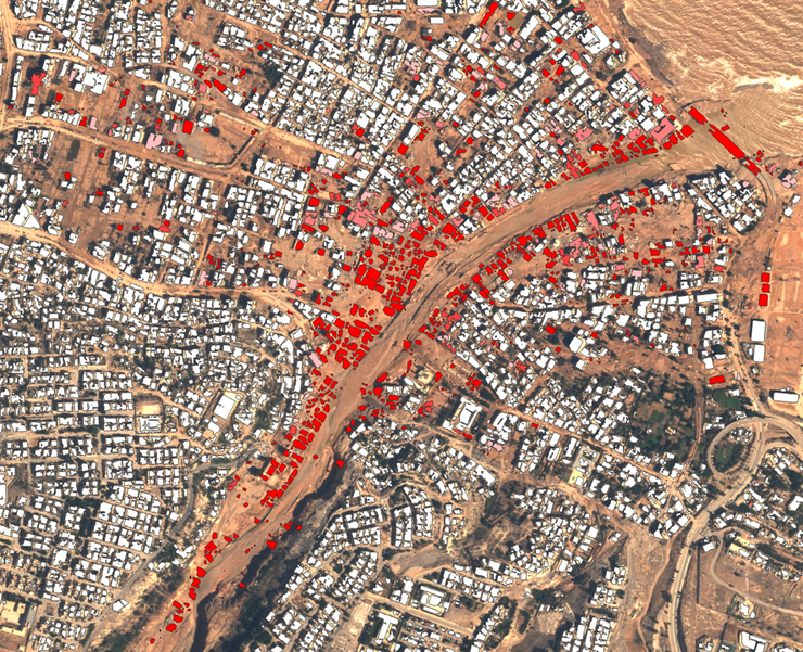
Fig 5 (page 11).
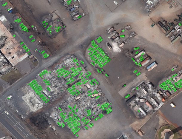
Fig 6 (page 11).
Limitations
- Damage detectable only from overhead; interior damage under intact roofs is missed.
- Damage outside known footprints (rubble beyond building outlines) may be missed, causing conservative (high specificity, low sensitivity) maps.
- Dependent on accuracy and recency of building footprint layers; misalignment or outdated footprints degrade embedding method accuracy.
- Cloud cover obscures portions of scenes, leaving many footprints unassessable.
- Validation primarily against visual interpretation of imagery rather than extensive ground-truth field surveys.
- Preliminary experiments collapse damage to binary labels and do not test distribution shift or more granular damage levels.
- Repeated assessments show model disagreement and require co-registration for robust temporal damage/change detection.
Open questions / follow-ons
- How vision-language and large multimodal models could improve zero- or few-shot damage assessment and explainability in disaster contexts.
- Integration of active learning to optimally select which buildings to label to accelerate model convergence.
- Methods to incorporate temporal sequences and repeated passes to quantify true damage change vs. model variability.
- Extending the platform to damage mapping of roads, bridges, and other infrastructure beyond buildings.
Why it matters for bot defense
For bot-defense practitioners, the HASTE platform illustrates a successful human-in-the-loop system that rapidly adapts models to a new domain with minimal labeled data and no pre-event baseline imagery, echoing challenges often faced in online fraud or bot detection scenarios where data shifts and label scarcity occur. The approach of using pretrained embeddings coupled with lightweight, interactive classifiers retrained client-side can inspire similar adaptive defenses that update rapidly with minimal analyst effort.
While HASTE focuses on geospatial damage assessment, the principles of interactive labeling, embedding pooling, and fast incremental retraining can inform techniques in CAPTCHA solving detection or adaptive bot classification that must generalize quickly to new bot behaviors or environments without large curated datasets.
Cite
@article{arxiv2607_11838,
  title={ HASTE: A Platform for Rapid Post-Disaster Building Damage Assessment },
  author={ Caleb Robinson and Anthony Ortiz and Simone Fobi Nsutezo and Cameron Birge and Meygha Machado and Marcelo Duarte and Joaquin Rivero Rodriguez and Anthony Cintron Roman and Kevin White and Inbal Becker-Reshef and Juan M. Lavista Ferres },
  journal={arXiv preprint arXiv:2607.11838},
  year={ 2026 },
  url={https://arxiv.org/abs/2607.11838}
}