
FLORA: A deep learning approach to predict forest attributes from heterogeneous LiDAR data
Source: arXiv:2606.32023 · Published 2026-06-30 · By Emilie Vautier, Clément Mallet, Cédric Vega
TL;DR
The paper addresses the challenge of predicting diverse forest structural attributes at a national scale from highly heterogeneous airborne LiDAR data. Traditional forest attribute models often struggle to generalize beyond local acquisition conditions due to variability in sensors, flight parameters, phenology (leaf-on vs leaf-off), and scan angles. To overcome these limitations, the authors propose FLORA, a deep learning framework that operates directly on raw LiDAR point clouds using an octree-based convolutional neural network backbone enhanced with auxiliary ecological and spatiotemporal data through a late-fusion gating mechanism. This architecture enables the model to adapt to heterogeneous data acquisition contexts and forest types. The model is trained and evaluated on 32,052 National Forest Inventory (NFI) plots covering mainland France and captures structural diversity across multiple species, forest types, acquisition seasons, and instrumentation.
Experimental results demonstrate that a single FLORA model trained on both leaf-on and leaf-off data outperforms season-specific models, achieving a cross-season robustness not found in existing methods. The model achieves relative RMSE of about 12.3% (R²=0.88) for dominant height and 39% (R²=0.74) for total volume, providing a strong baseline for large-scale forest attribute estimation from heterogeneous LiDAR datasets. Auxiliary variables such as forest composition and acquisition timing yield modest overall gains but are especially helpful for species-specific volume predictions. This work establishes the value of voxel-based deep learning combined with multisource contextual data for robust nationwide forest monitoring under variable LiDAR acquisition contexts.
Key findings
- FLORA achieves approximately 12.3% relative RMSE (R² ≈ 0.88) for dominant height estimation on a nationwide French NFI dataset of 32,052 plots.
- For total volume estimation, FLORA attains about 39% relative RMSE with R² ≈ 0.74.
- A single FLORA model trained jointly on leaf-on and leaf-off LiDAR data outperforms models trained only on season-specific data, improving cross-season robustness significantly.
- Including auxiliary ecological and spatiotemporal variables improves prediction accuracy, particularly for species-specific volume estimation, though overall gains are modest compared to LiDAR data alone.
- Voxel-based octree convolutional neural network backbone combined with an HRNet architecture better preserves forest structural information compared to point-based methods.
- Restricting LiDAR input features to 3D XYZ coordinates (excluding intensity and scan angle) improves robustness across acquisition campaigns by reducing sensor-specific biases.
- Spatial overlap of NFI plots with multiple LiDAR acquisition conditions helps anchor the model to paired observations, enhancing generalization.
- Forest types dominated by deciduous species (68% of sample) show strong phenology-induced variability, which FLORA can accommodate via multi-season training.
Threat model
n/a — This work addresses a regression/generalization challenge for predicting forest inventory attributes from varied LiDAR acquisitions without immediate consideration of adversarial threats or bot-defense scenarios.
Methodology — deep read
Threat model & assumptions: The study assumes a 'benign' data environment focused on accurately predicting forest attributes given heterogeneous LiDAR acquisition conditions. The primary challenge is data heterogeneity from varied flight parameters, sensors, phenology (leaf-on/off), and forest composition rather than active adversarial interference.
Data provenance, size, labels, splits, preprocessing:
- The dataset consists of 32,052 NFI plots across mainland France linked to classified airborne LiDAR point clouds from the French National LiDAR HD program.
- The LiDAR data exhibit significant heterogeneity in sensor types, flight altitudes, scan angles, seasons (leaf-on/leaf-off), surveyed over multiple years.
- Plots with acquisition-to-field-survey date difference less than 5 years were included.
- Plots were filtered based on canopy height model completeness, canopy cover agreement, and disturbance indicators to ensure quality.
- NFI field data provide ground-truth forest attributes including dominant height, total volume, deciduous and coniferous volume, basal area, and stem density.
- Auxiliary variables include spatial coordinates, forest composition types, canopy cover classes, sylvo-ecoregions, and temporal acquisition features encoded using embeddings and sinusoids.
- Architecture / algorithm:
- Input: Raw 3D LiDAR points represented as octree voxel structures, limited to spatial coordinates (XYZ).
- Backbone: Octree Convolutional Neural Network combined with a High-Resolution Net (HRNet) adapted for octree inputs, extracting multi-resolution feature maps via residual bottleneck blocks and cross-scale fusion.
- Auxiliary data: Encoded via a separate MLP producing learned embeddings concatenated late in the network after HRNet stages, allowing adaptive gating of LiDAR and contextual information.
- Output: Multilayer perceptron for multi-target regression producing estimates of six forest attributes.
- Targets are normalized by z-score per attribute to balance training loss contribution and back-transformed for evaluation.
- Training regime:
- Hyperparameters (learning rate, weight decay, batch size) optimized via grid search given the multi-attribute regression.
- Training performed on large-scale heterogeneous data, details on epochs, optimizer, or hardware are not clearly described in the excerpt.
- Dropout applied post-feature concatenation for regularization.
- Evaluation protocol:
- Metrics: relative RMSE (rRMSE) and coefficient of determination (R²) for each predicted forest attribute.
- Comparisons between single-season trained models and multi-season FLORA models assess cross-season robustness.
- Ablations examine the impact of auxiliary variable inclusion and plot overlap with multiple acquisitions.
- Large spatial coverage and diverse phenology and acquisition conditions test national-scale generalization.
- Reproducibility:
- The paper does not mention code release or public availability of trained models.
- The dataset is comprised of national data but exact public access conditions are unclear.
Example flow: A single NFI plot’s classified LiDAR point cloud is converted into an octree voxel representation capturing 3D forest structure. Auxiliary plot context features are encoded. These inputs pass through the octree-HRNet backbone and MLP modules, producing normalized predictions for dominant height, volumes, basal area, and stem density. Predictions are back-transformed to original units and compared to ground truth NFI measurements. Training is repeated on thousands of such plots with diverse LiDAR acquisition conditions to learn a robust model adaptable to season and instrumentation heterogeneity.
Technical innovations
- Application of octree convolution combined with HRNet architecture directly to raw LiDAR point clouds for large-scale national forest attribute regression from heterogeneous data.
- Late-fusion gating mechanism to integrate heterogeneous ecological and spatiotemporal auxiliary data with LiDAR geometric features, improving adaptability to acquisition conditions.
- Training a single model on multi-season (leaf-on/leaf-off) LiDAR data to improve cross-season robustness and transferability, unlike prior season-specific models.
- Use of exclusively spatial XYZ coordinates as input features (excluding intensity, return number, scan angle) to reduce sensor-specific biases and improve robustness.
Datasets
- French National Forest Inventory (NFI) plots — 32,052 plots with field measurements — national forestry survey data (semi-permanent plots on 1 km grid)
- French National LiDAR HD program — airborne LiDAR point clouds with minimum 10 pts/m² density — national large-scale heterogeneous acquisitions covering mainland France
Baselines vs proposed
- Season-specific models (leaf-on only or leaf-off only): rRMSE increases by ~16-26% for coniferous and deciduous volume predictions compared to FLORA multi-season model.
- LiDAR-only FLORA model (no auxiliary data): rRMSE ~13.5% for dominant height vs full model with auxiliary data rRMSE ~12.3%.
- Random Forest baseline from literature: RMSE of canopy height ~3.0m (R²=0.74) on regional heterogeneous datasets vs FLORA dominant height R²=0.88 at national scale.
- Single-season trained deep learning models underperform in cross-season predictions compared to FLORA trained jointly on leaf-on and leaf-off acquisitions, which maintain more stable errors.
Figures from the paper
Figures are reproduced from the source paper for academic discussion. Original copyright: the paper authors. See arXiv:2606.32023.
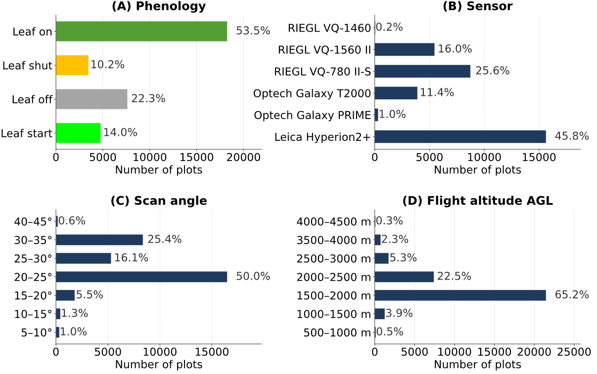
Fig 1: Variability of our plot-level LiDAR dataset in terms of phenology, sensor, scan
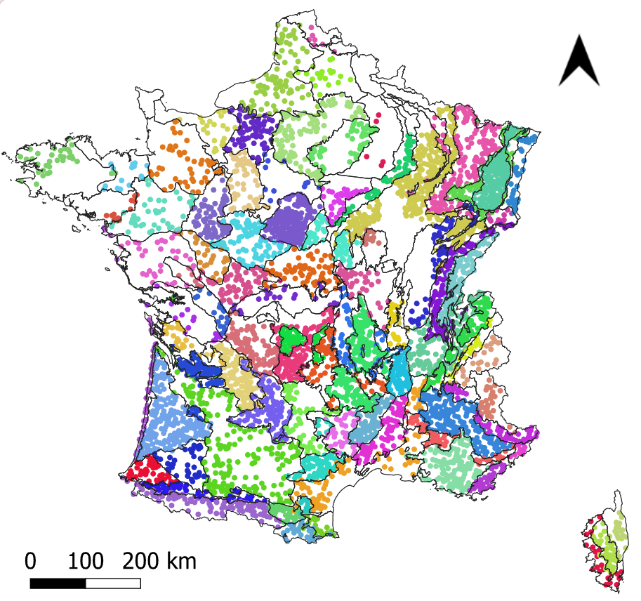
Fig 2: Spatial distribution over France of the NFI plots used in this study, colored with
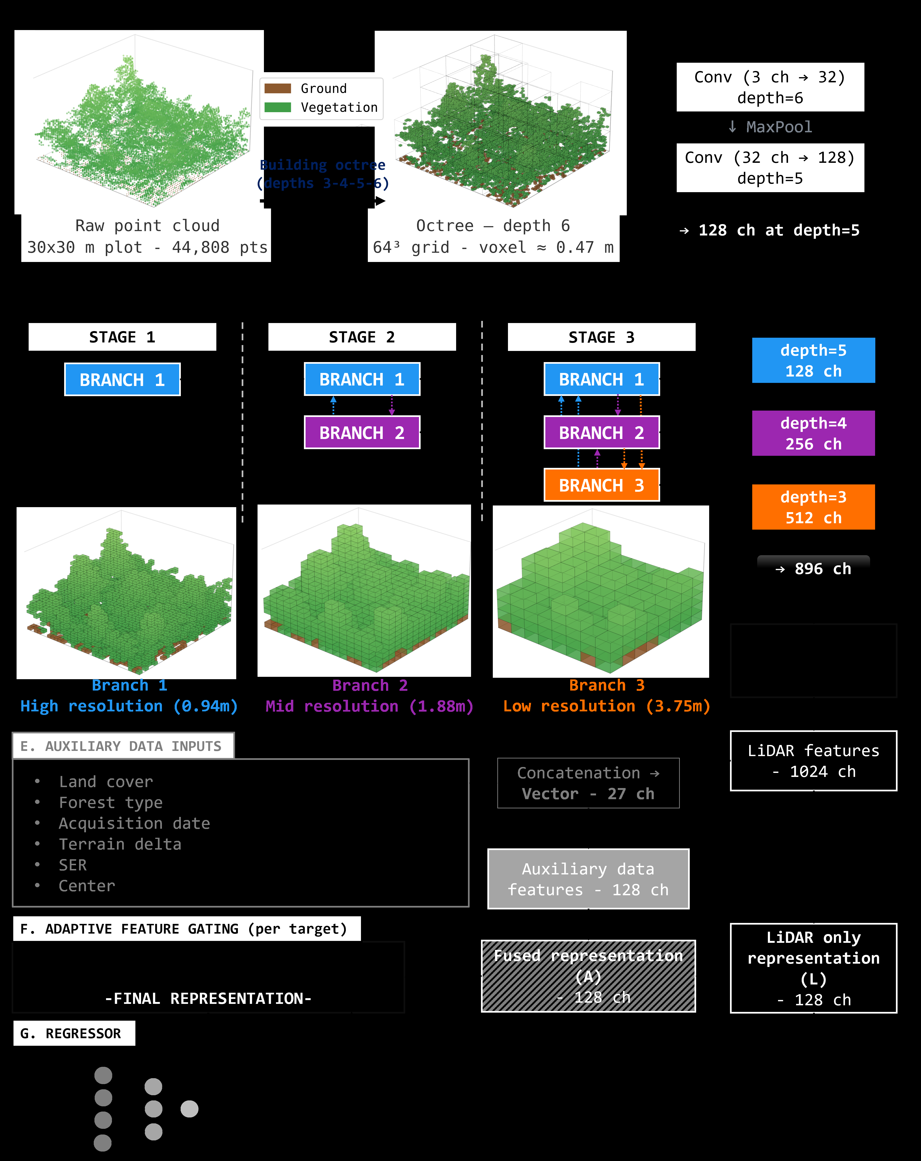
Fig 3: Step-wise description of FLORA. ch stands for channels, and indicates the size of
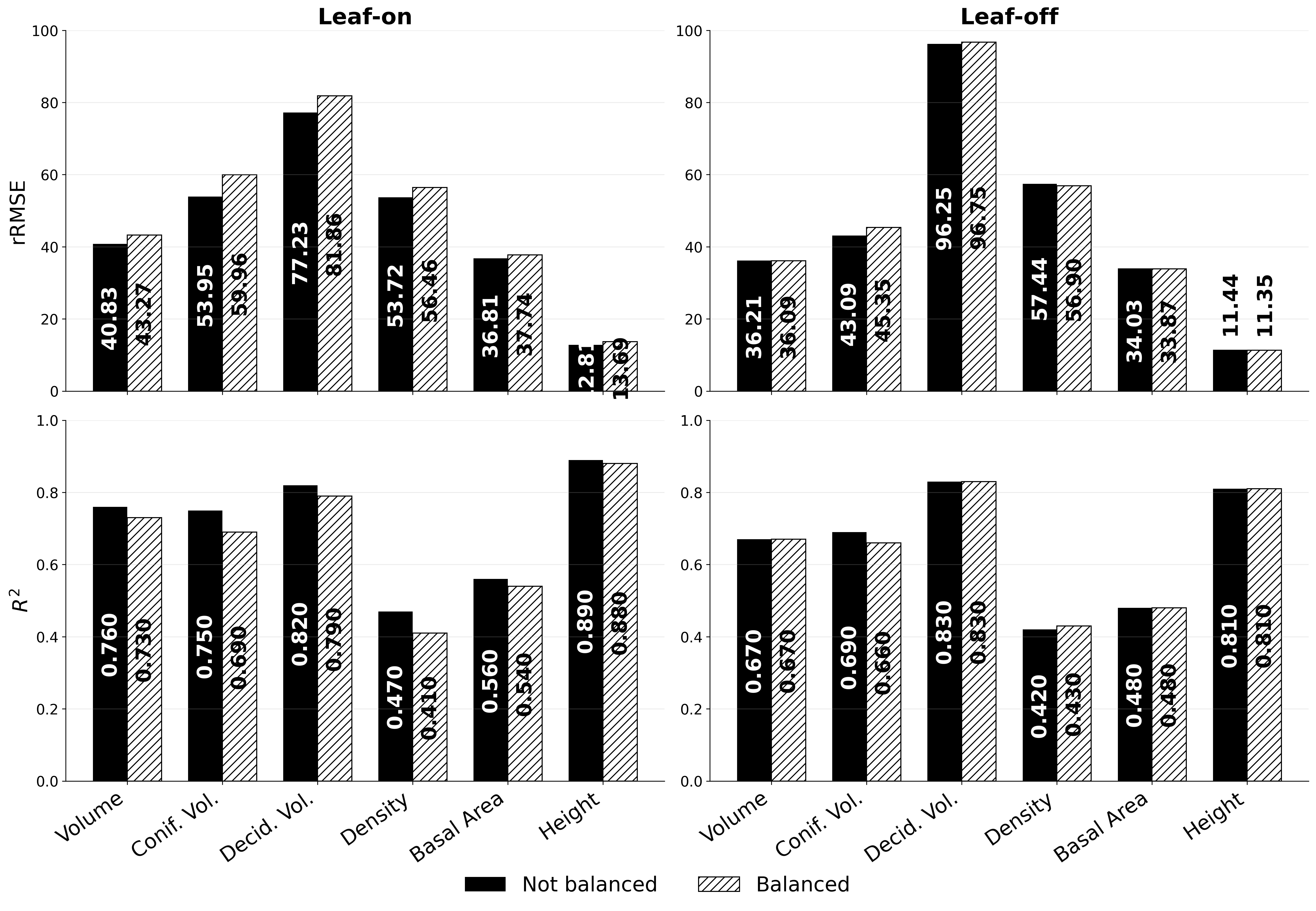
Fig 4: Comparison of predictive performance between the full model (solid black bars)
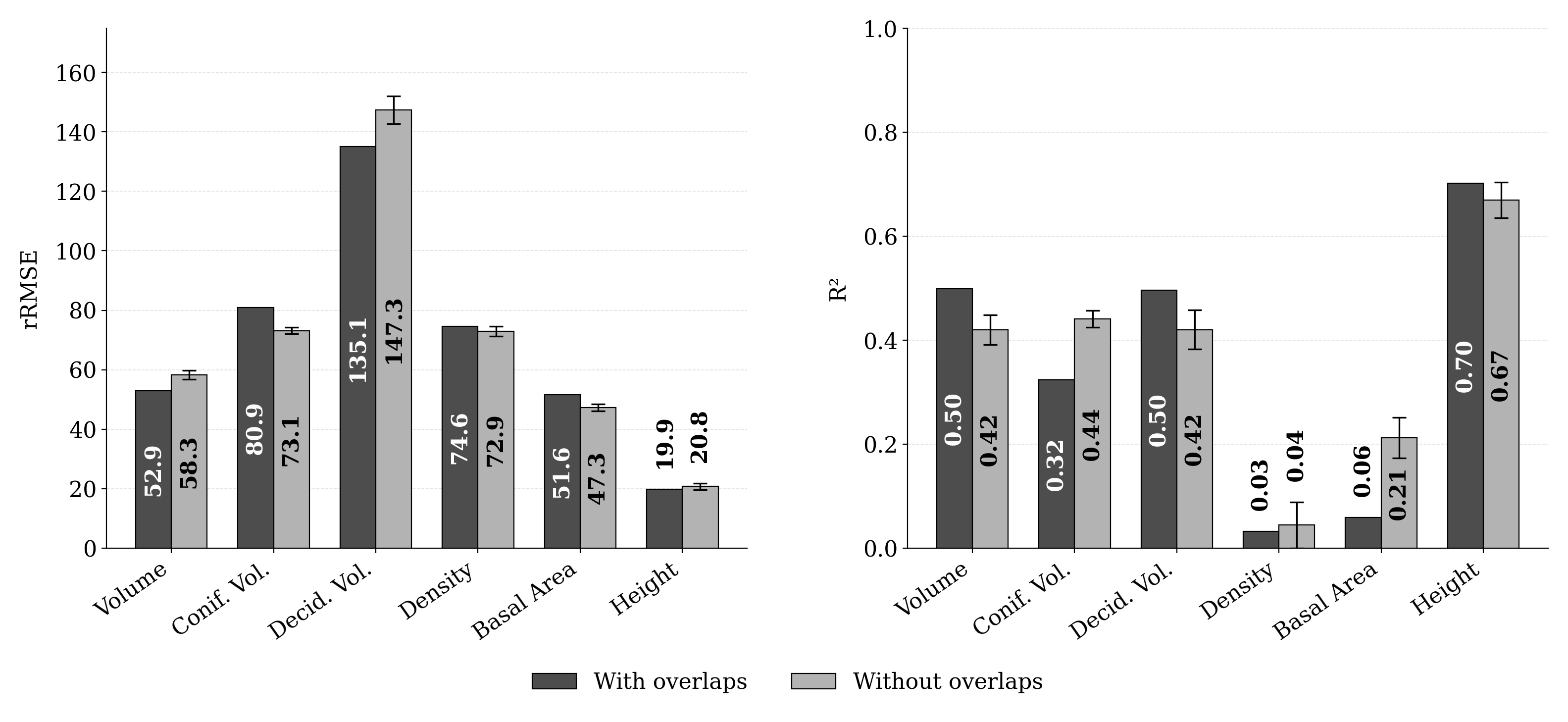
Fig 5: Effect of spatial overlap between LiDAR acquisitions on model performance. Met-
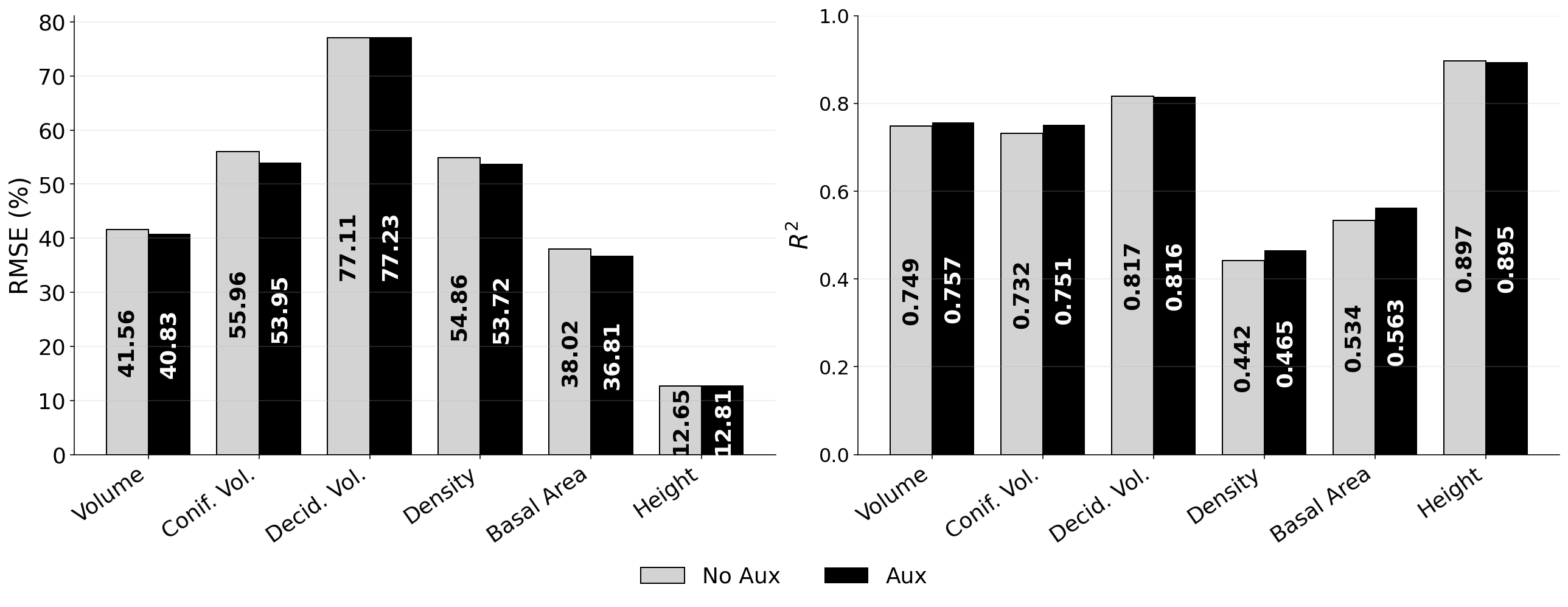
Fig 6: Barplots showing changes in rRMSE and R2 between the LiDAR-only baseline (No
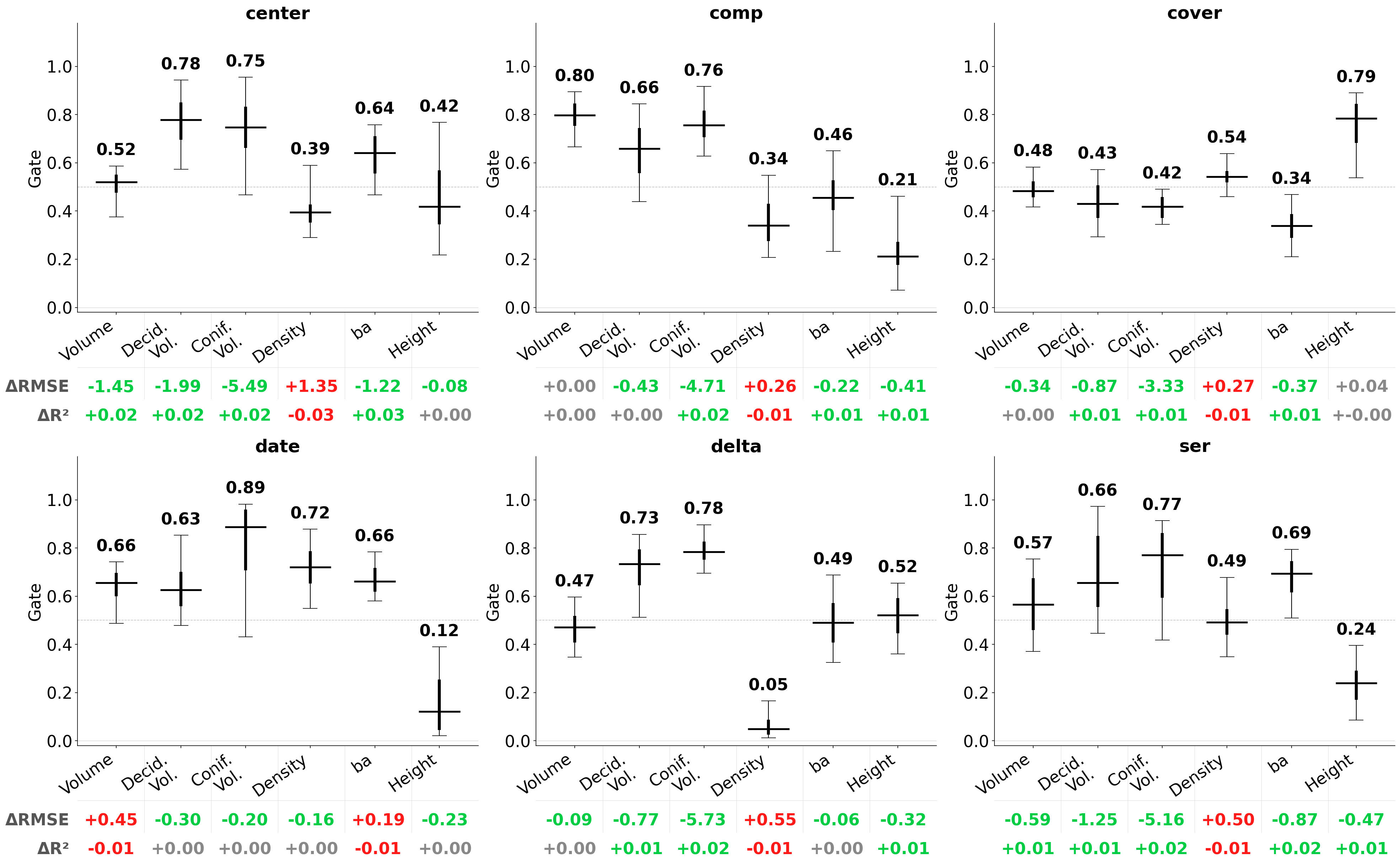
Fig 7: Distribution of learned gating coefficients for each auxiliary data configuration
Limitations
- The model is not directly evaluated under active adversarial conditions or on proof-of-robustness against intentional data manipulation.
- The heterogeneous dataset is restricted to French forests; generalization to other biomes or countries remains untested.
- Intensity and echo-related LiDAR features are excluded, possibly limiting finer discrimination under some conditions.
- Exact training parameters and hardware details are not fully specified, which may affect reproducibility.
- No open source code or pretrained model weights are indicated as available.
- The model doesn’t directly address how temporal forest changes between LiDAR acquisition and field survey affect predictions beyond basic filtering.
Open questions / follow-ons
- Can the FLORA framework and architecture generalize effectively to other forest ecosystems with different species compositions and acquisition conditions?
- How can the model be extended to incorporate additional available LiDAR features (intensity, multiple returns) with calibrated sensors to further improve accuracy?
- What are the limits of transferability when applied to temporally distal LiDAR and field data with larger acquisition-to-survey gaps?
- Can the late-fusion gating mechanism be made interpretable enough to systematically identify acquisition biases and automatically correct for them?
Why it matters for bot defense
While this paper does not focus on bot-defense or CAPTCHA technologies, its contributions in handling large-scale heterogeneous 3D LiDAR data via robust voxel-based deep learning and context-dependent auxiliary fusion can inform the design of advanced bot-detection systems that must generalize across heterogeneous input distributions. Specifically, FLORA’s approach to managing variability in sensor conditions and contextual metadata through late fusion and multi-resolution feature extraction might inspire similar architectures for anti-bot applications that must work reliably under changing environment or data acquisition conditions. The emphasis on single-model multi-condition training to improve cross-domain robustness could translate to strategies for building CAPTCHA or bot-detection models resistant to variations in input modalities or attacker methods. However, the domain differences mean direct application is limited and would require substantial adaptation. Bot-defense engineers might find the methodological rigor around heterogeneous data training and auxiliary data integration instructive for designing resilient ML defenses.
Cite
@article{arxiv2606_32023,
  title={ FLORA: A deep learning approach to predict forest attributes from heterogeneous LiDAR data },
  author={ Emilie Vautier and Clément Mallet and Cédric Vega },
  journal={arXiv preprint arXiv:2606.32023},
  year={ 2026 },
  url={https://arxiv.org/abs/2606.32023}
}