
From Rubble Simulation to Active Magnetic Mapping: Quantum Sensing for Disaster Response
Source: arXiv:2606.25957 · Published 2026-06-24 · By Samuel Tovey, Stefan Prestel, Hiroshi Yamauchi
TL;DR
This paper addresses the critical challenge of locating survivors trapped in collapsed buildings within the first 72 hours, where timely structural information about the rubble is vital. Existing sensing modalities offer partial and indirect insights. The authors propose a novel integrated pipeline leveraging drone-based quantum magnetometry to directly sense magnetic fields induced by steel-reinforced concrete debris. Using a physics-based rubble-collapse simulation in Unreal Engine, they generate realistic rubble meshes and compute magnetic fields via a per-triangle dipole approximation. The magnetic field magnitude at typical drone standoff altitudes (1-2 meters above rubble) falls within the sub-picotesla to sub-nanotesla range, detectable by modern nitrogen-vacancy (NV) center quantum magnetometers. Sparse multi-sensor measurements collected by a drone-mounted array are then fused using Gaussian Process Regression (GPR) driven by Bayesian active sampling to reconstruct continuous magnetic field maps efficiently.
Their experiments show that a three-sensor drone array optimizes the trade-off between sensing payload and reconstruction fidelity, outperforming single- or four-sensor configurations. Adaptive sampling guided by predictive uncertainty reaches near-peak structural correlation with roughly 100 samples, compared to slower or less consistent coverage from deterministic flight paths. The pipeline reliably recovers key structural features across multiple independent rubble realizations, validating both the physics modeling and the autonomous mapping approach. Results suggest that quantum-grade magnetometry can provide actionable void detection and structural analysis information for disaster response drones, augmenting existing sensing technologies.
Key findings
- Magnetic fields induced by collapsed steel-reinforced concrete rubble span ~30 pT to 3 µT near the source surface, falling to sub-pT to sub-nT range at 1-2 m drone standoff (Fig 2,3).
- Quantum magnetometer sensitivity in the sub-pT to sub-nT range is sufficient to discern the building outline and surviving pillars from above the rubble.
- Sparse sampling with a three-sensor array yields robust Gaussian Process Regression reconstructions with Pearson correlations ~0.85-0.90 at meter-scale sensor inter-element spacing (Fig 5,6).
- Increasing array size beyond three sensors offers diminishing or inconsistent gains, and single-sensor arrays perform unreliably.
- Bayesian active sampling reaches peak structural map correlation in ~100 samples, outperforming lawnmower (slow, steady) and sine-wave (phase-sensitive) deterministic flight paths (Fig 7).
- Reconstructions generalize across multiple independent rubble collapse realizations with varying fracture geometries, indicating robustness.
- Larger sensor spacings (up to 2 m) improve recovery of spatial gradients and field structure but impose UAV payload and mounting constraints.
- Below the rubble roofline, magnetic field becomes noisy and the dipole approximation breaks down, suggesting that airborne drone sensing should operate above the roof.
Threat model
The threat is a natural disaster scenario: building collapse due to earthquake-like lateral impulse generating rubble with unknown but statistically modeled fracture patterns. The adversary is environmental complexity and structural randomness. The drone platform is assumed to have onboard precise localization and quantum magnetometers with sufficient sensitivity. The adversary cannot manipulate the drone sensors or environment actively; the problem is passive sensing of variable rubble structures under environmental noise.
Methodology — deep read
The authors formulate a simulation and mapping pipeline consisting of three main stages:
Threat Model & Assumptions: The adversary is conceptualized as the natural environment causing structural rubble collapse, with unknown precise geometry but characterized statistically via random-fracture parameters simulating earthquake-like damage. The drone platform is assumed to possess accurate pose information and quantum magnetometers capable of sub-pT to sub-nT sensitivity. The approach assumes a known Earth magnetic field from NOAA models, and neglects remnant magnetization and complex magnetic coupling effects.
Data Generation & Preprocessing: They create realistic rubble meshes of a steel-reinforced concrete parking garage collapse using Unreal Engine's Chaos physics simulation. The building is 28m x 28m x 5m with 31 supporting columns and a concrete roof. Sudden lateral impulses induce random fracture patterns via Voronoi tessellation with block grouping to mimic rebar-reinforced fracture groups, generating varied collapse geometries. Two independent collapse realizations with different random seeds are generated for robustness testing.
The magnetic field is computed from the mesh using a per-triangle dipole approximation. Each triangle slab induces a magnetic moment proportional to its area and Earth's magnetic field multiplied by a relative permeability estimate (µr = 30). Fields are calculated at grid points representing aerial standoff positions (horizontal planes 1-7m above ground) spanning a 40x40x10m volume, as well as sparse samples mimicking drone flight paths.
- Architecture / Algorithm: Sparse multi-sensor measurements are modeled as observations of the magnetic field norm ∥B∥ at discrete waypoints collected by drone-mounted arrays of varying sensor counts (1 to 4 sensors arranged at 0.3m offsets). Field maps are reconstructed using Gaussian Process Regression (GPR) with Radial Basis Function (RBF) kernels plus white noise to model measurement uncertainty.
Next drone sampling points are selected by Bayesian active sampling using the Upper Confidence Bound (UCB) acquisition function with large exploration weight (κ → ∞) to greedily sample locations with highest predictive uncertainty. This adaptively balances exploration to build an accurate magnetic field map efficiently.
Training Regime: The pipeline is run on an NVIDIA H100 GPU using the JAX library for fast vectorized computation. Hyperparameters of the GPR kernel are optimized with 5 random restarts using scikit-learn, yielding stable fits (error ~ 10^-8). Experiments are repeated 20 times with different random seeds for the active sampler to estimate uncertainty bounds.
Evaluation Protocol: Reconstruction quality is measured by the Pearson correlation between the GPR-predicted magnetometry map and the dipole ground truth over the drone flight operating plane. Results examine sensor array size, sensor spacing (5 cm to 2 m), and flight path strategies: lawnmower (deterministic zig-zag), sine-wave sweeping, and Bayesian active sampling. Multiple rubble realizations validate generality. Figures 4-7 provide detailed quantitative comparisons.
Reproducibility: Code, simulation data, and rubble meshes can be made available upon reasonable request. The methods use publicly available software for physics simulation (Unreal Engine), Gaussian Processes (scikit-learn), and magnetic modeling with known parameterizations. However, no public repository or frozen weights are provided in the paper.
Concrete example pipeline: For one collision simulation, the rubble mesh is generated with random fracture parameters, dipole-induced field computed over a 250^3 grid, and drone-mounted three-sensor array collects ~100 sparse samples over an active-sampling-guided flight path at 7m altitude. GPR trained on these samples reconstructs magnetic magnitude maps with ~0.9 Pearson correlation to ground truth, recovering structural features such as remaining pillars and roof fragments.
Technical innovations
- Integration of a physics-based rubble collapse simulation in Unreal Engine with dipole magnetic field modeling tailored for drone quantum magnetometry.
- Use of a per-triangle dipole approximation combined with a Gaussian Process Regression back-end to reconstruct continuous magnetic field maps from sparse multi-sensor drone measurements.
- Application of Bayesian active sampling with UCB acquisition to efficiently guide drone sampling, achieving peak reconstruction quality in roughly 100 samples.
- Demonstration that a three-sensor drone array balances payload constraints and gradient resolution for optimal structural mapping fidelity.
- Quantitative characterization of sensor array spacing impact on field gradient estimation and reconstruction accuracy in disaster rubble environments.
Datasets
- Unreal Engine simulated rubble collapse meshes — 2 independent realizations — generated by proprietary Unreal Engine Chaos plugin with randomized fracture parameters
Baselines vs proposed
- Single-sensor array: Pearson correlation ~0.6-0.7 vs three-sensor array: ~0.85-0.9 (Fig 5)
- Four-sensor array: marginal or inconsistent gains compared to three-sensor array, sometimes regressing in correlation (Fig 5)
- Lawnmower flight path: slow but steady increase in reconstruction correlation, peaking after >200 samples (Fig 7)
- Sine-wave flight path: faster increase but phase-sensitive, with variable peak correlation (Fig 7)
- Bayesian active sampling: reaches peak structural correlation (~0.9) in ~100 samples, outperforming both deterministic baselines (Fig 7)
Figures from the paper
Figures are reproduced from the source paper for academic discussion. Original copyright: the paper authors. See arXiv:2606.25957.
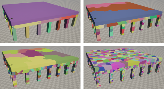
Fig 1: Fracture groups in the Unreal Engine Chaos
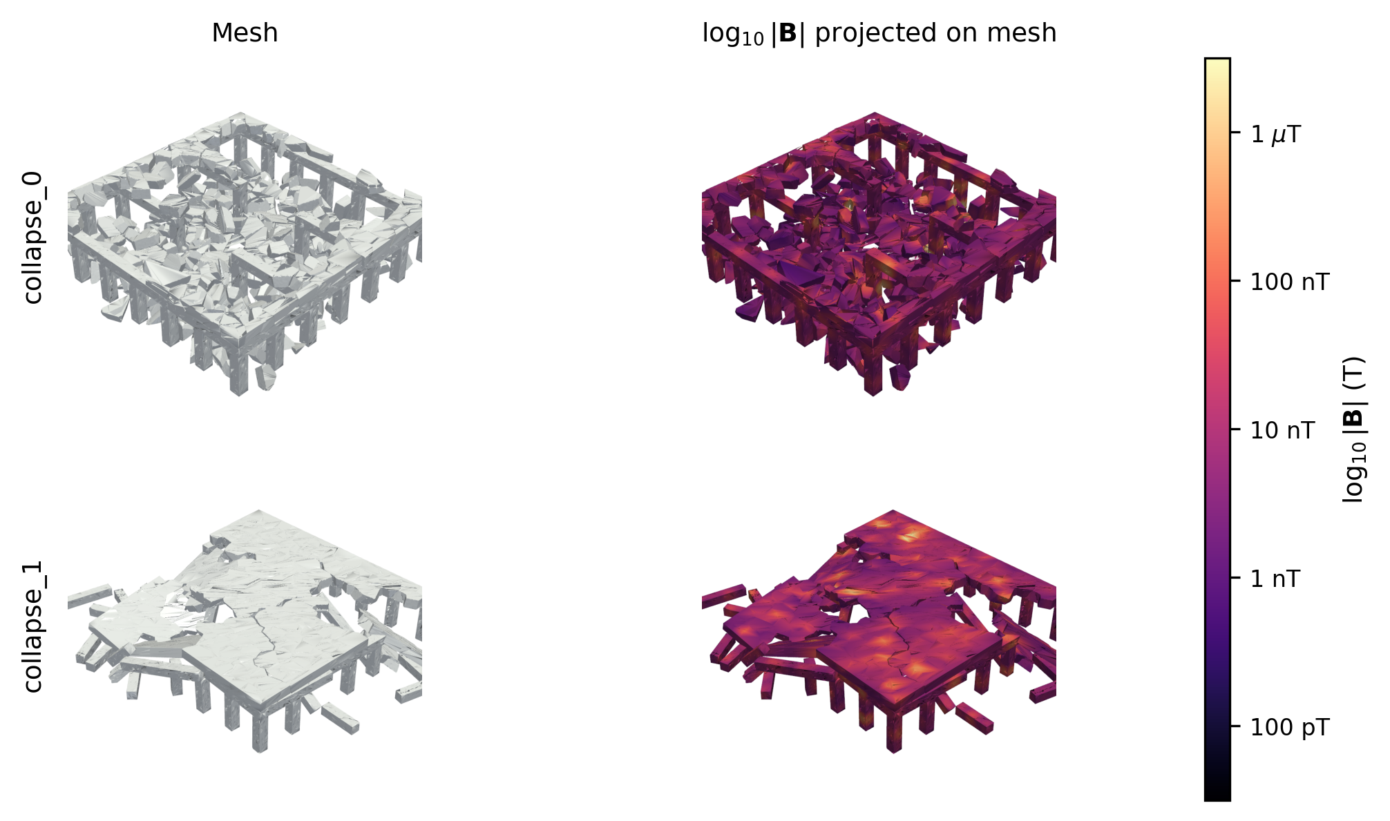
Fig 2: Two independent collapse realizations (top and bottom rows). Left column: bare rubble mesh. Right
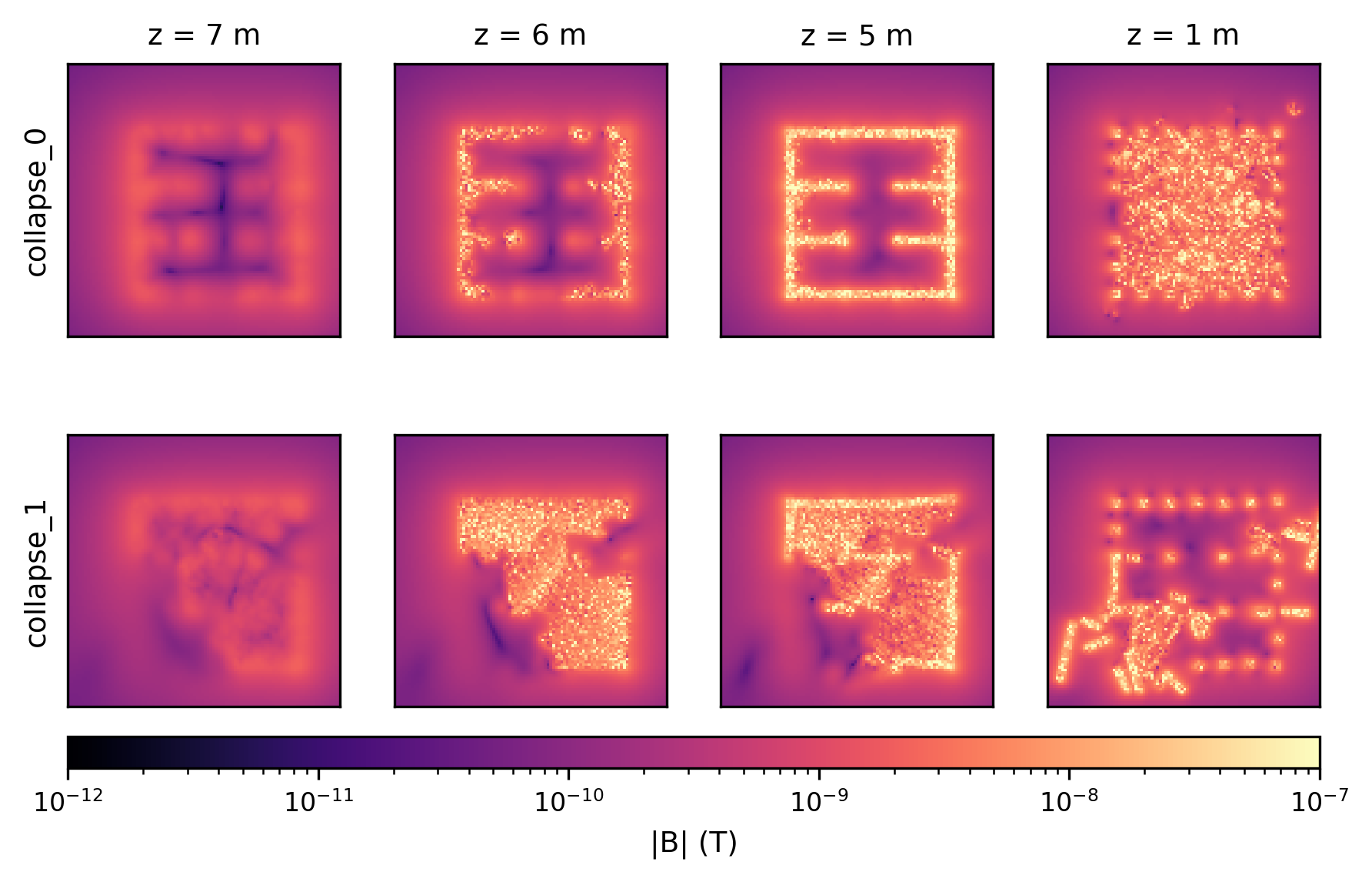
Fig 3: Horizontal field slices at z = 7, 6, 5, 1 m above ground for two independent collapse realizations (rows).
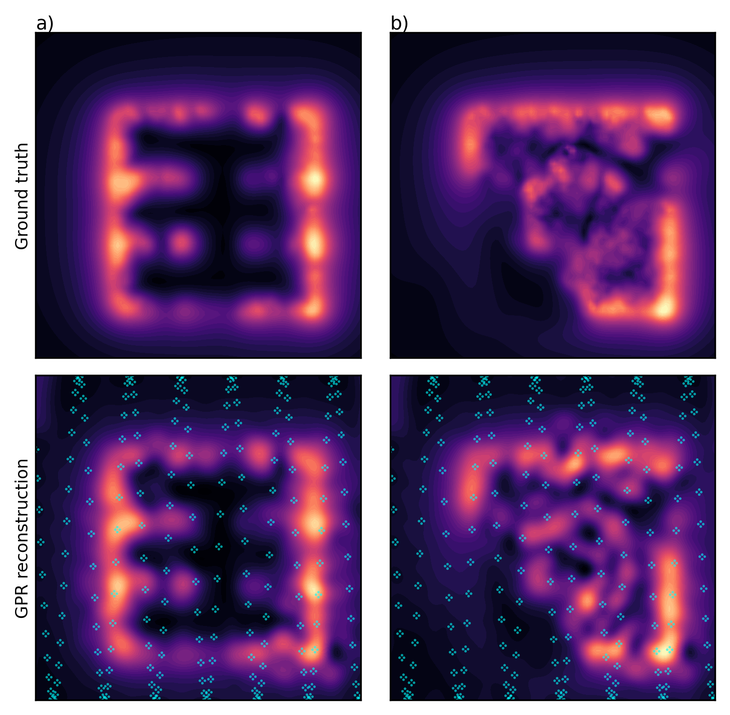
Fig 4: Sparse-sample GPR reconstruction over two collapse realizations, a) collapse_0 and b) collapse_1.
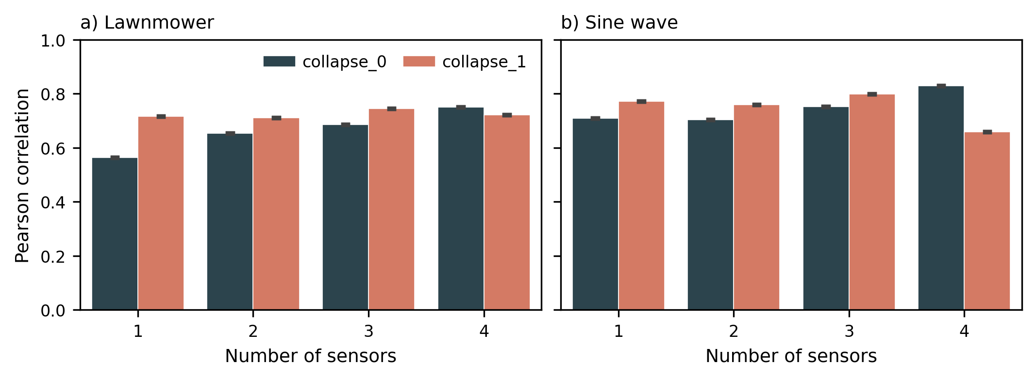
Fig 5: Pearson correlation between GPR reconstruction and ground truth as a function of sensor count for two
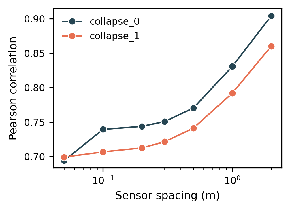
Fig 6: Pearson correlation between GPR recon-
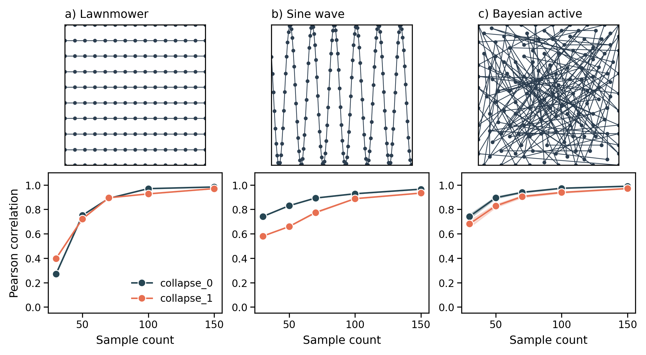
Fig 7: Sampling strategies as a function of sample budget. Top row: representative drone trajectory for a)
Limitations
- Dipole approximation neglects remnant magnetization, mesh-to-mesh field coupling, and intact rebar survival effects in rubble, simplifying magnetic field modeling.
- Simulations assume accurate and stable drone pose; localization errors or GPS-denied realities are not addressed.
- Magnetic noise and sensor imperfections (finite coherence times, measurement noise) are not explicitly modeled or folded into the reconstruction.
- Tests limited to two independent rubble realizations; wider variety of collapse types and materials remain unexplored.
- Active sampling acquisition function uses pure exploration limit and could benefit from budget-aware termination or trade-off between exploration and exploitation.
- No field validation with physical drone flights or real sensor data to complement simulations.
- Mapping limited to a single horizontal plane at fixed altitude; vertical adaptive sampling remains future work.
Open questions / follow-ons
- How to incorporate remnant magnetization, mesh-to-mesh magnetic interactions, and partial rebar survival into more physically accurate magnetic field models?
- What is the impact of realistic sensor noise characteristics, finite T*2 coherence times, and measurement errors on reconstruction fidelity?
- Can adaptive sampling algorithms be extended to three-dimensional waypoint selection and variable flight altitudes for improved mapping efficiency?
- How can the reconstructed magnetic maps be integrated directly into automated void detection and rubble stability assessment frameworks to aid rescue operations?
Why it matters for bot defense
This work presents a novel sensing and reconstruction pipeline leveraging quantum magnetometry to map sub-surface structures in disaster rubble, enabling drone-borne detection of survivors’ voids and structural integrity. For bot-defense and CAPTCHA practitioners, while the domain differs, the paper illustrates robust sparse signal acquisition combined with Gaussian Process Regression and Bayesian active learning for rapid autonomous mapping under resource constraints. The methodology of active sampling to maximize information gain with limited queries and sensor payload optimization could inspire analogous approaches in adaptive challenge design or bot behavior modeling.
Moreover, the paper highlights handling noisy measurement environments, multi-sensor fusion, and uncertainty-guided exploration, elements relevant for dynamic challenge adjustment and adversarial detection. Though not a direct bot-defense or CAPTCHA technique, the interdisciplinary fusion of physics-informed simulation, probabilistic regression, and autonomous sampling offers a methodology blueprint for efficient, robust, and adaptive sensing of latent states—a core problem in bot-detection where attackers seek to hide in complex behavior patterns.
Cite
@article{arxiv2606_25957,
  title={ From Rubble Simulation to Active Magnetic Mapping: Quantum Sensing for Disaster Response },
  author={ Samuel Tovey and Stefan Prestel and Hiroshi Yamauchi },
  journal={arXiv preprint arXiv:2606.25957},
  year={ 2026 },
  url={https://arxiv.org/abs/2606.25957}
}