
Hedgementation = Hedgerow Segmentation: A Remote Sensing Benchmark
Source: arXiv:2606.23615 · Published 2026-06-22 · By Nathan Senyard, Salem Hamdani, Astrid Zhang, Derek Wang, Evan Shelhamer, Mathias Lécuyer et al.
TL;DR
This paper presents Hedgementation, a new benchmark for hedgerow segmentation from remote sensing imagery at country scale with 10m resolution. Hedgerows are critical linear landscape features providing biodiversity and ecosystem services but are under-monitored at large scale due to costly field inventories. The authors compile and harmonize multispectral Sentinel-2 satellite imagery, Alpha Earth Foundations embeddings, and a unique, updated French national hedgerow inventory (BD Haie v2) to provide data covering all of France with 20+ million hedgerows represented. They propose a semantic segmentation task focusing on mapping these thin linear features and evaluate three baseline approaches including two deep networks (PASTIS U-TAE and FTW) and classical ML on embeddings (random forest, logistic regression, kNN). Results show best baseline IoUs around 40%, with clear performance degradation over distant test locations and different climatic zones (temperate vs subtropical). The study reveals hedgerow mapping challenges tied to spatial generalization and climatic/agricultural variability, and offers an open, reproducible benchmark for future remote sensing and agricultural ML research.
Key findings
- The best segmentation result by the PASTIS U-TAE model achieves a mean IoU of 0.416 across all test patches.
- Performance degrades 2-5% IoU when predicting hedgerows on test patches ≥28km from training patches (near vs far test sets).
- In subtropical climatic zones, IoU is consistently lower (~0.374) compared to temperate zones (~0.424) even with climate-specific training.
- Restricting training to agricultural zones reduces performance, but evaluation on agricultural pixels yields a higher IoU (up to 0.459) than all pixels (0.410).
- Simpler models using AEF embeddings with random forest and logistic regression achieve IoUs between 0.20 and 0.24, substantially lower than deep networks.
- Across 2,995 patches resampled from 600,000+ original patches, only ~5% of pixels correspond to hedgerows, highlighting the class imbalance challenge.
- Spatial buffering in data splitting ensures no overlaps between train/val/test patches, enforcing robust spatial generalization evaluation.
Threat model
n/a — this work is a remote sensing segmentation benchmark and does not consider adversarial or malicious threat actors. The focus is on generalization challenges of ML models in large-scale spatial and climatic variability rather than security scenarios.
Methodology — deep read
The paper targets the problem of automatic hedgerow detection from remote sensing at a national scale, emphasizing generalization across space and climate. The threat model assumes a typical ML training scenario where models have access to labeled hedgerow data from certain spatial locations and must generalize to unseen regions and climate zones—no adversarial attack scenario is considered.
Data is derived primarily from Sentinel-2 satellite imagery (ESA harmonized, surface reflectance, 10m resolution, 10 spectral bands from multispectral instrument), collected from Sept 2021 to Oct 2022 via Google Earth Engine. Images with >20% cloud coverage are removed. The Alpha Earth Foundations (AEF) annual embeddings representing learned feature summaries at 10m resolution for 2022 are also used as alternative inputs. The ground-truth hedgerow labels come from BD Haie inventory version 2, which integrates aerial photo interpretation, farmer validation in agricultural zones, and automatic segmentation over all France. Hedgerows are represented as lines with no width, buffered to 7m width, rasterized at 0.5m and downsampled to 10m resolution to match imagery.
The data is split into 1.28km × 1.28km patches (128×128 pixels) totaling 603,564 points, subsampled to 2,995 patches balancing computational cost and data diversity. Patches are assigned to five spatial folds with 28km buffer zones to mitigate spatial leakage across train/val/test, preserving robust evaluation of spatial generalization. Agricultural parcel boundaries and FAO global agro-ecological zones (10km resolution) annotate patches as agricultural or non-agricultural and temperate or subtropical climate zone for analysis.
Two deep baseline architectures are evaluated: (1) PASTIS U-TAE, a U-Net style network with temporal attention from prior remote sensing semantic segmentation work, adapted for 10 spectral bands and binary hedgerow output without architecture changes; (2) Fields of The World (FTW) model, trained on fewer spectral bands and two seasonal composite images, preprocessed to fit the model’s input specification. Both deep models are trained from random initialization with standard training protocols (epochs, batch size, optimizer details not fully specified). Additionally, the AEF embeddings are used with classical ML models (kNN with spatial context, random forest, logistic regression), trained on balanced subsets restricting positive labels to confident interior hedgerow pixels.
Evaluation uses the Intersection-over-Union (IoU) metric on binary rasterized hedgerow masks thresholded at >0 presence probability. Performance is analyzed across near vs far spatial folds, climatic zones, and agricultural vs non-agricultural pixels, using 5-fold cross-validation. Qualitative patch visualizations supplement quantitative scores. The benchmark includes public code and dataset preparation scripts for reproducibility, though BD Haie labels originate from a closed government data source. The full dataset is large, but published subsampled splits and code facilitate replication.
A concrete example would be training PASTIS U-TAE on 1,797 patches of Sentinel-2 10-band data with corresponding binary masks, then evaluating IoU on 599 test patches located ≥28km from training patches. Evaluation shows ~41.6% IoU, with reduced IoU in subtropical zones and on non-agricultural pixels.
Overall, the methodology rigorously curates multiple data sources, harmonizes spatial resolution, and applies robust train-test splits with buffered folds to benchmark spatial generalization for a fine-scale linear mapping challenge in remote sensing.
Technical innovations
- Compilation and harmonization of large-scale, multisource remote sensing imagery (Sentinel-2), embeddings (AEF), and a detailed, updated national hedgerow vector inventory (BD Haie v2) into a harmonized raster dataset at 10m resolution suitable for ML.
- A spatially buffered five-fold cross-validation splitting strategy over country-scale patches that ensures non-adjacent train/validation/test groups to rigorously test spatial generalization including far (>28km) test zones.
- Benchmarking of both supervised deep semantic segmentation and self-supervised embedding-based models on a challenging fine-scale linear feature mapping task with extremely sparse positive classes (~5%) in large satellite images.
- Cross-climatic zone and agricultural vs non-agricultural zone evaluation framework elucidating model difficulties in generalizing across agro-ecological gradients relevant to agricultural monitoring.
Datasets
- Hedgementation benchmark dataset — 2,995 patches (128x128 pixels) subsampled from 603,564 initial patches covering all France — composed of Sentinel-2 imagery (10 spectral bands, Sept 2021–Oct 2022), Alpha Earth Foundations embeddings (2022), and BD Haie v2 hedgerow labels (French National Geographic Institute, 2024)
Baselines vs proposed
- PASTIS U-TAE full data: IoU = 0.416 (avg over near and far test folds)
- PASTIS U-TAE near test: IoU = 0.410; far test: IoU = 0.389 (performance drop due to spatial distance)
- FTW model full data: IoU = 0.31 vs PASTIS U-TAE full data: 0.416
- AEF Random Forest embeddings: IoU = 0.235 vs PASTIS U-TAE full data: 0.416
- AEF Logistic Regression embeddings: IoU = 0.206 vs PASTIS U-TAE full data: 0.416
- AEF kNN embeddings: IoU = 0.151 vs PASTIS U-TAE full data: 0.416
- Training on temperate only: IoU on temperate test = 0.372, on subtropical test = 0.287 (large generalization gap)
- Training on subtropical only: IoU on subtropical test = 0.331, on temperate test = 0.357 (smaller gap)
- Evaluation on agricultural pixels only: PASTIS U-TAE IoU = 0.459 vs all pixels IoU = 0.410
Figures from the paper
Figures are reproduced from the source paper for academic discussion. Original copyright: the paper authors. See arXiv:2606.23615.
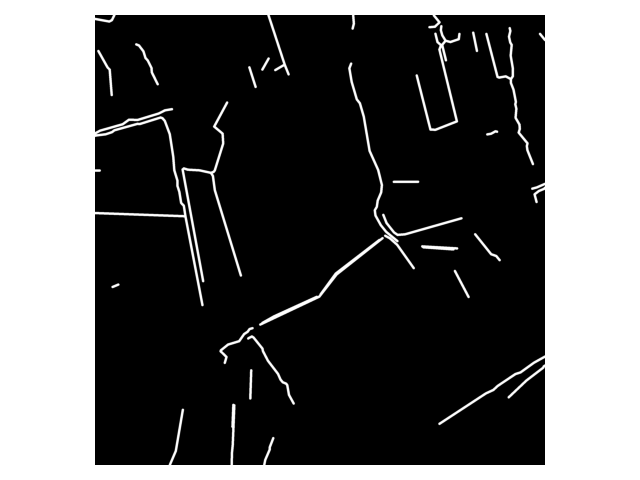
Fig 1: Hedgerow label rasterization process, applied to one patch: spatial detail is preserved.
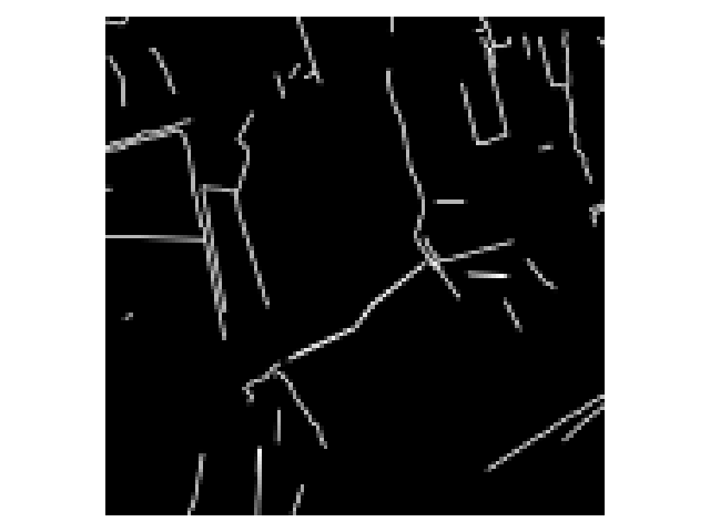
Fig 2: Dataset creation process: (2a) France is split into large tiles, randomly assigned to folds
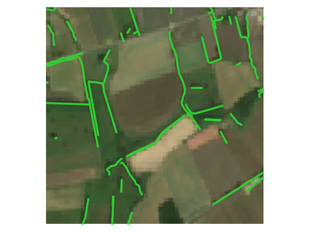
Fig 3 (page 3).
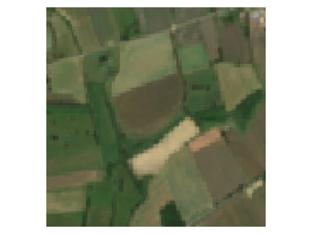
Fig 4 (page 3).
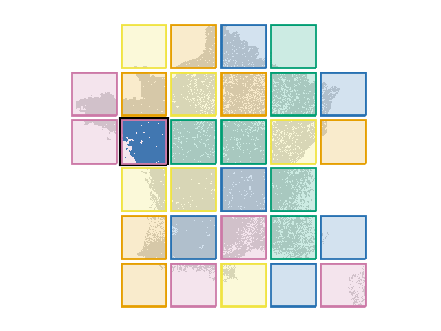
Fig 5 (page 3).
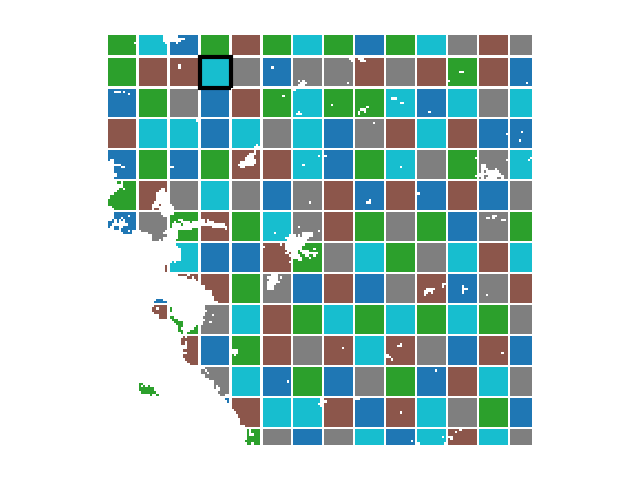
Fig 6 (page 3).
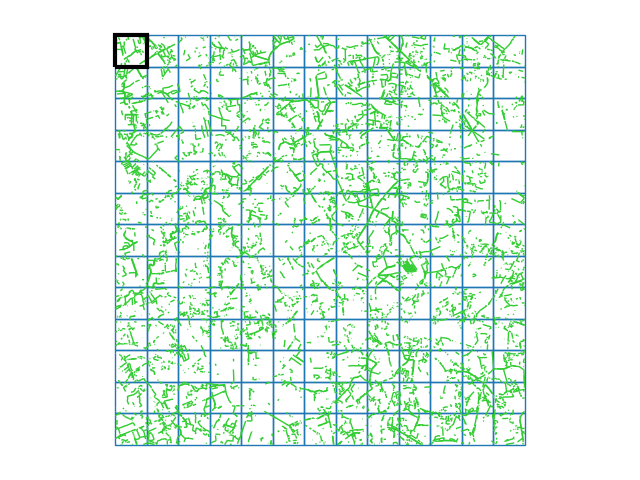
Fig 7 (page 3).
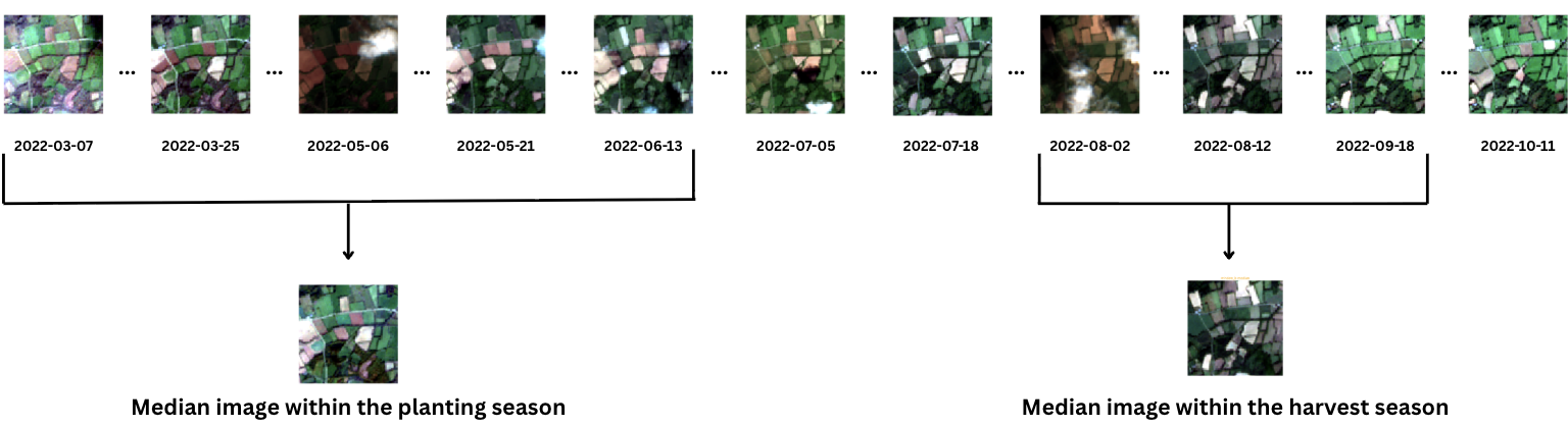
Fig 3: Input data for the FTW model: the model requires two input images taken from two
Limitations
- BD Haie label data, while high-quality and ground validated, may contain noise and inconsistency due to varied detection methodologies across regions and years.
- The rasterization process assumes a fixed 7m buffer width for hedgerow lines, which might oversimplify variable natural hedgerow widths and shapes.
- Performance is still modest (40-45% IoU), indicating considerably room for improvement; baseline models were adapted from different tasks without specific architectural tuning for hedgerows.
- Evaluation focuses on generalization across spatial distance and climate zones but does not test temporal generalization or model robustness to sensor variation or atmospheric conditions.
- The dataset subsampling (moving from 600k+ patches to ~3k patches) may limit coverage of rare or complex hedgerow types and landscape heterogeneity.
- Embeddings-based methods may be limited by annual temporal resolution, lacking fine temporal dynamics captured by multispectral images.
Open questions / follow-ons
- Can domain adaptation or specialized spatial-temporal modeling methods close the performance gap across climatic zones for rare or complex hedgerow types?
- How do multi-temporal or higher spatial resolution data improve fine-scale linear feature segmentation compared to annual embeddings or 10m multispectral images?
- What are the impacts of alternative hedgerow width representations or vector-LiDAR fusion on segmentation accuracy and label fidelity?
- Can self-supervised or foundation model approaches pretrained on broad remote sensing data significantly improve transferability and generalization in architecture design tailored to fine linear features?
Why it matters for bot defense
For bot-defense practitioners, this paper illustrates the challenges of detecting small, fine-grained, irregular linear objects in large-scale satellite imagery, similar to how CAPTCHAs or bot-detectors may need to recognize subtle cues in noisy or sparse input data. The benchmark’s rigorous spatial buffering and climatic zone partitioning highlight the importance of robust generalization to unseen geographic regions or conditions—an analogous concern for CAPTCHAs deployed globally. The combination of multimodal inputs (raw spectral bands, embeddings) and the pitfalls of limited annotated data emphasize designing defenses or recognition systems that can leverage rich but heterogeneous inputs and carefully curated label data. Furthermore, the evaluation on rare, sparse classes with severe class imbalance parallels the challenges in bot detection where signals are weak and scattered.
Though focused on environmental remote sensing, the methods for data harmonization, explicit train-test spatial decorrelation, and multi-input benchmarking provide a useful methodological template to design CAPTCHA/anti-bot systems that must operate reliably at global scale, cope with distribution shifts, and reconcile diverse sensor quality or environmental noise.
Cite
@article{arxiv2606_23615,
  title={ Hedgementation = Hedgerow Segmentation: A Remote Sensing Benchmark },
  author={ Nathan Senyard and Salem Hamdani and Astrid Zhang and Derek Wang and Evan Shelhamer and Mathias Lécuyer and Joséphine Gantois },
  journal={arXiv preprint arXiv:2606.23615},
  year={ 2026 },
  url={https://arxiv.org/abs/2606.23615}
}