
RO-LiDAR GeoQuickView: A Web Platform for Exploring Public LiDAR-Derived Elevation Data in Romania
Source: arXiv:2606.08876 · Published 2026-06-07 · By Alexandru Hegyi
TL;DR
This paper addresses the challenge of fragmented delivery and high barriers to reuse of public LiDAR-derived elevation data in Romania. The author presents RO-LiDAR GeoQuickView, a non-commercial web GIS platform designed to harmonize, visualize, and enable spatial discovery of multi-source LiDAR digital terrain models (DTMs) and complementary elevation datasets at various resolutions. The platform integrates detailed 0.5 m resolution LAKI III Zone A DTMs covering several counties, with plans to incorporate Zone B after public release and quality validation. It also includes legacy LAKI II and other public altimetric sources, applying a source-aware ingestion workflow to accommodate heterogeneous data acquisition units and spatial extents. The system offers standardized hillshade browser views for immediate terrain inspection plus direct raster retrieval for advanced GIS reuse, thus lowering technical barriers while preserving provenance and data accountability. The platform emphasizes transparent limitations and is positioned as an accessibility layer rather than a replacement for official or specialized products.
Key findings
- RO-LiDAR GeoQuickView currently integrates 0.5 m resolution LAKI III Zone A DTMs covering 4 counties: Caraş-Severin, Gorj, Mehedinţi, and Dolj.
- The platform harmonizes and quality-controls LAKI II data at 1 m resolution for western Romanian counties including Arad, Bihor, Hunedoara, and Alba.
- It supports browsable hillshade visualizations generated with a fixed illumination angle (azimuth 315°, solar elevation 35°) for standardized terrain perception.
- Source-aware acquisition units range from 1 km LAKI III cells to larger 40 km × 40 km blocks in LAKI II and other complementary datasets, preserving data provenance.
- Users can retrieve original raster tiles directly via a spatial index map for independent GIS processing beyond browser exploration.
- The platform explicitly distinguishes exploratory browser visualization from rigorous expert interpretation, emphasizing limitations of DTMs and hillshades (e.g., ground classification errors, directional lighting bias).
- RO-LiDAR GeoQuickView supports multiple landscape sectors, including geomorphology, hydrology, forestry, agriculture, planning, archaeology, education, and public participation.
- The roadmap targets integration of LAKI III Zone B coverage (Suceava, Neamţ, Bacău, Vrancea) following public release and continued metadata and delivery improvements.
Threat model
n/a — This paper focuses on data accessibility and visualization of public elevation datasets without addressing adversarial threats, security concerns, or robustness to malicious inputs.
Methodology — deep read
Threat Model & Assumptions: The work assumes an open data environment where public elevation products are sourced from official providers like ANCPI. There is no adversarial threat model addressed, as the platform focuses on data accessibility and visualization rather than security. Users range from casual explorers to GIS specialists needing provenance-respecting raster retrieval.
Data: The primary data includes multi-resolution LiDAR-derived DTMs from Romanian national projects LAKI II (~1 m resolution) and LAKI III (0.5 m for Zone A and soon Zone B). Data provenance is heterogeneous: LAKI III is tiled into one-kilometre acquisition cells, whereas LAKI II and complementary datasets use larger provider-specific blocks (up to 40 km square). Public elevation products vary in spatial extent, acquisition date, resolution, and processing lineage.
Architecture / Algorithm: The platform is implemented as a Web-GIS built on ESRI's ArcGIS Experience Builder, allowing configurable responsive web interfaces. A source-aware spatial index tracks individual raster acquisition units by project and resolution class. Harmonization workflows standardize coordinate reference systems (EPSG:3844 Stereo70), inspect metadata, validate completeness, and mosaic source units into county/regional extents. Standard hillshade derivatives are generated analytically using a fixed illumination azimuth (315°) and solar angle (35°) for consistent terrain shading.
Training Regime: Not applicable; this is primarily a data processing and platform engineering effort.
Evaluation Protocol: The platform quality controls data assets by checking for NoData gaps, anomalous pixel values, and visible edge artefacts before mosaic assembly. Visualization standards and documentation transparency highlight the interpretation limits of hillshade and DTMs. The author references prior Romanian studies utilizing the data for hydrological modeling, forestry, archaeology, demonstrating practical alignment with known applications.
Reproducibility: The web application is openly accessible at the cited URL. Source elevation datasets remain property of their original providers; the platform focuses on standardized, documented harmonization steps preserving provenance. No machine learning models or training weights are involved.
Concrete Example: For the LAKI III Zone A, spatial index cells of 1 km are programmatically queried against the ANCPI public source catalog, downloaded only when the cell data package exists and passes metadata validation. After reprojection and clipping, these cells are mosaicked per county, checked for artefacts, and hillshade rasters are generated. These visual and raster assets are published via the web GIS interface, enabling users to click on the county map to retrieve individual 1 km cell raster packages for local GIS use.
Technical innovations
- A source-aware processing workflow that transparently handles heterogeneous LiDAR acquisition units ranging from fine 1 km tiles to larger provider blocks, preserving provenance in the harmonized dataset.
- Integration of multiple LiDAR-derived DTMs and complementary elevation models into a single web-accessible platform supporting both immediate browser visualization and direct raster retrieval for user reuse.
- Standardized hillshade visualization with fixed illumination parameters to provide immediate, interpretable terrain shading across diverse datasets with varying resolutions and qualities.
- Dual-access layered architecture separating casual terrain exploration through web GIS from advanced reuse requiring source raster downloads and independent GIS processing.
Datasets
- LAKI III Zone A — approx. 50,000 km² coverage in 4 counties — publicly released by ANCPI, 0.5 m resolution, tiled in 1 km² cells
- LAKI III Zone B — pending public release, same resolution and planned integration
- LAKI II — approx. 50,000 km² coverage in western counties — publicly released by ANCPI, 1 m resolution, provider-specific larger blocks (~40 km × 40 km)
- Complementary elevation models — various national altimetric products with 1–5 m resolution across Romania — public sources, provider-specific blocks
Figures from the paper
Figures are reproduced from the source paper for academic discussion. Original copyright: the paper authors. See arXiv:2606.08876.
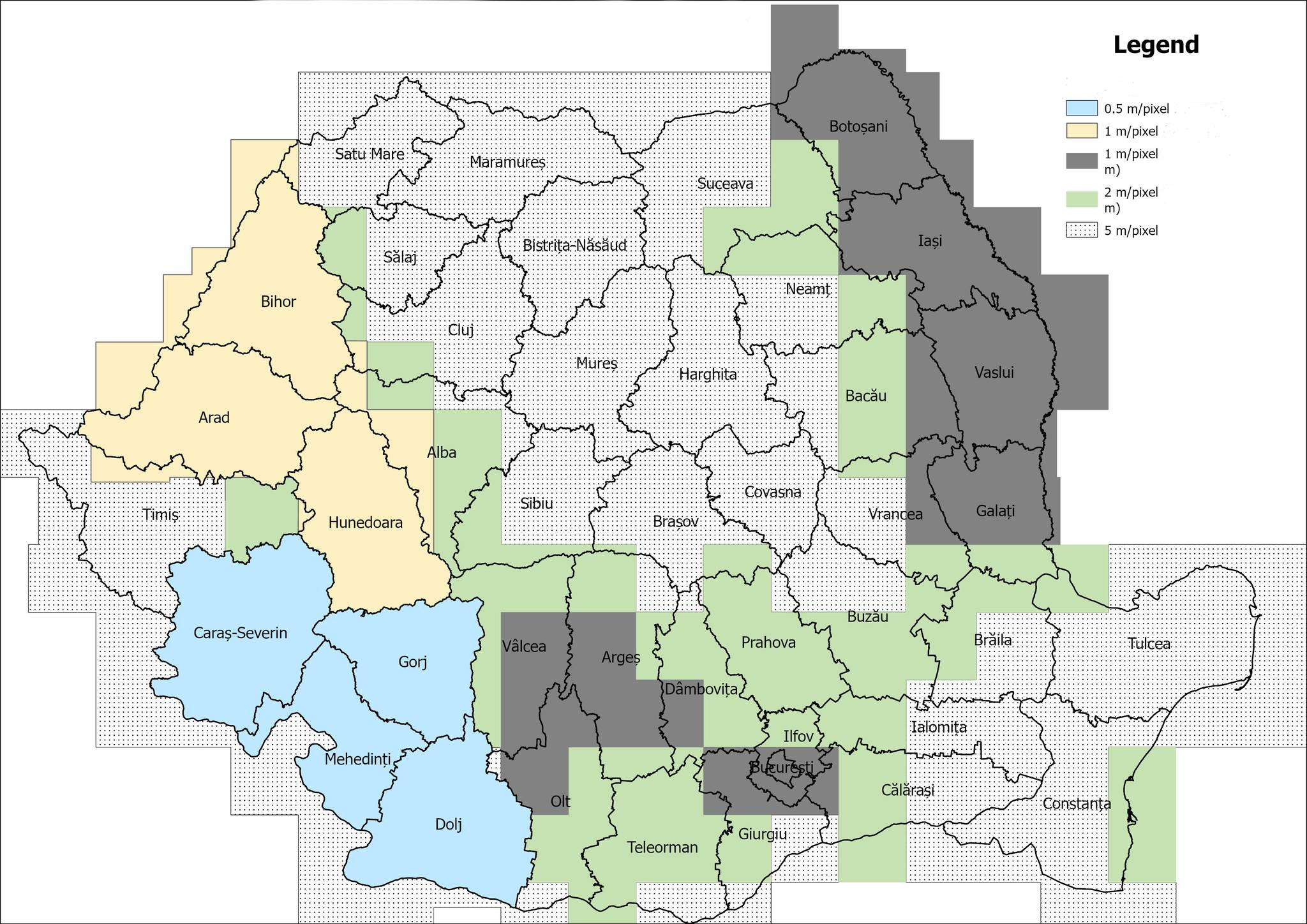
Fig 1: Spatial distribution and nominal ground resolution of
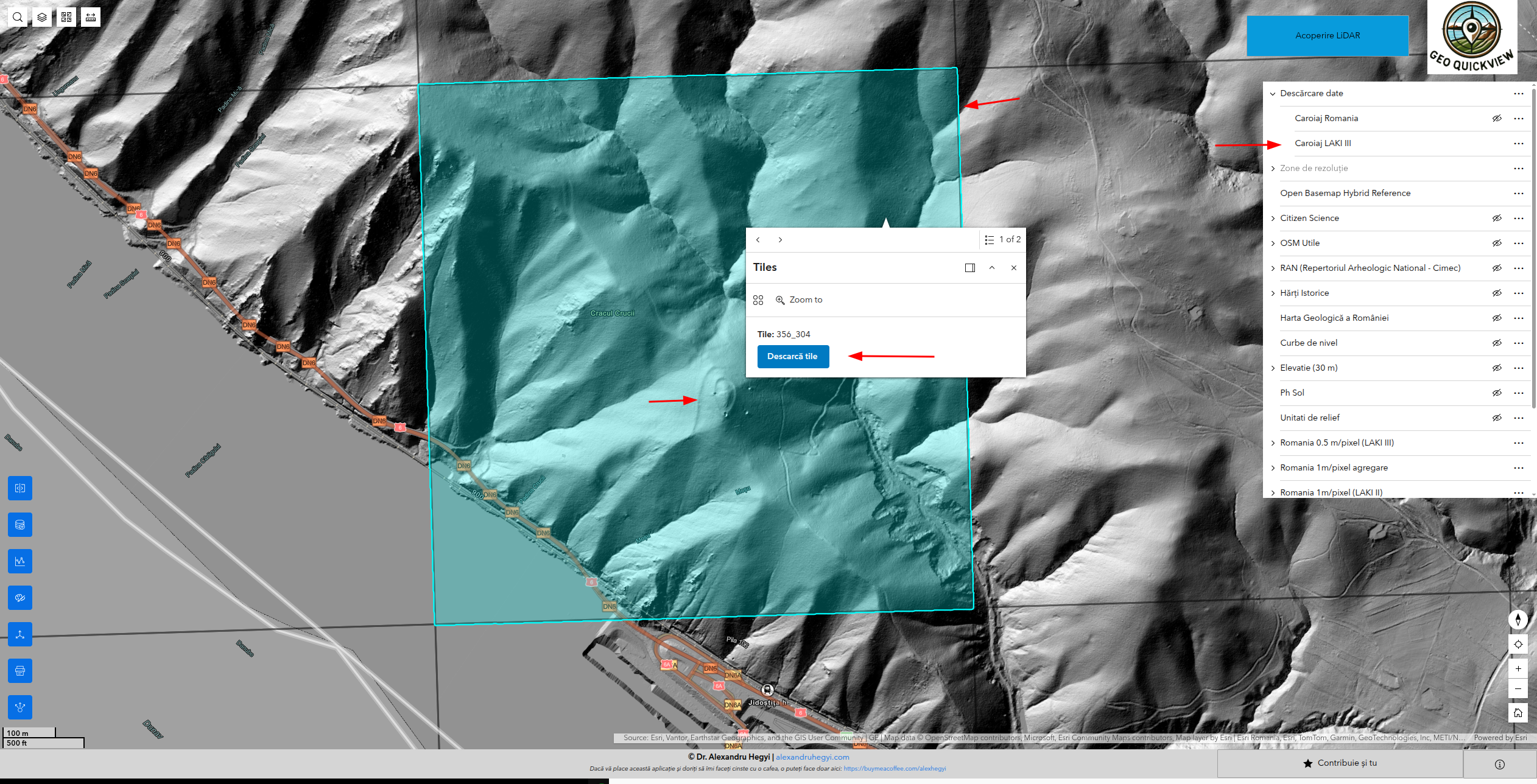
Fig 2: Source-aware workflow of RO-LiDAR GeoQuickView. Acquisition units vary by provider, while the platform applies a
Limitations
- Coverage is heterogeneous with variation in spatial resolution, acquisition dates, processing methods, and dataset completeness, limiting uniform interpretation.
- Digital terrain models are processed products relying on ground point classification, which may misclassify vegetation or remove genuine small-scale terrain features, affecting accuracy.
- Hillshade visualizations with fixed illumination direction can suppress features oriented towards the light source, causing directional bias in terrain perception.
- The platform does not perform advanced terrain modelling, expert review, or field verification; observations remain preliminary and require specialist validation.
- No integrated change detection or time series analysis for repeat LiDAR surveys has yet been implemented, limiting multi-temporal monitoring capabilities.
- Underlying elevation datasets remain property of original providers; licensing and attribution restrictions apply to reuse beyond the platform.
Open questions / follow-ons
- How to incorporate multi-directional or alternative hillshading and relief visualization methods to reduce directional bias and improve interpretability for non-expert users?
- What architecture and workflows would support scalable, web-optimized delivery of large multi-source elevation raster datasets beyond ArcGIS Experience Builder?
- How best to integrate multi-temporal LiDAR acquisitions into the platform for change detection and repeat-survey geomorphological monitoring?
- What participatory quality-control or expert review workflows can be developed to integrate user-contributed terrain observations alongside the elevation data?
Why it matters for bot defense
Although primarily a geospatial data accessibility platform, RO-LiDAR GeoQuickView exemplifies principles of integrating public heterogeneous datasets into an accessible web environment with source-aware provenance tracking and layered user access modes. Bot-defense and CAPTCHA practitioners can draw parallels to web-based systems that must ingest, harmonize, and expose large distributed data collections in user-friendly but authenticity-preserving ways. The source-aware indexing and dual visualization/download access model highlight scalable approaches for exposing complex datasets while controlling for data lineage and user capabilities. While no direct security mechanism or adversarial model is involved, the paper’s emphasis on layered access and provenance retention could inform architectural thinking in bot defense systems requiring multiparty data or layered user privileges. The explicit documentation of limitations and transparency around interpretation biases also serves as a reminder that defense systems must clearly communicate constraints to users of automated or semi-automated data services.
Cite
@article{arxiv2606_08876,
  title={ RO-LiDAR GeoQuickView: A Web Platform for Exploring Public LiDAR-Derived Elevation Data in Romania },
  author={ Alexandru Hegyi },
  journal={arXiv preprint arXiv:2606.08876},
  year={ 2026 },
  url={https://arxiv.org/abs/2606.08876}
}