
Robustness and Transferability of Pix2Geomodel for Bidirectional Facies Property Translation in a Complex Reservoir
Source: arXiv:2605.03919 · Published 2026-05-05 · By Abdulrahman Al-Fakih, Nabil Sariah, Ardiansyah Koeshidayatullah, Sherif Hanafy, SanLinn I. Kaka
TL;DR
This paper investigates the robustness and transferability of Pix2Geomodel, a conditional GAN-based framework for bidirectional translation between geological facies and petrophysical properties (porosity, permeability, and clay volume) in reservoir geomodeling. Unlike the original Pix2Geomodel study on a simpler reservoir with many vertical layers, this work applies the method to a more heterogeneous and complex reservoir characterized by only 54 retained layers and seven facies classes. The key challenge is to evaluate whether the Pix2Pix-based model can preserve spatial geological structures and facies-property relationships under these more constrained, realistic data conditions.
The authors prepare aligned high-resolution 2D slices of facies and petrophysical data, augment the dataset with consistent geometric transformations, and train the Pix2Pix model for six bidirectional tasks: facies to porosity, permeability, and VCL, and the inverse tasks. Evaluations include traditional image metrics (pixel accuracy, mean intersection over union) alongside spatial continuity assessment via experimental variograms. Results show the model successfully maintains dominant geological architecture and spatial-continuity patterns across most tasks, especially facies↔porosity and VCL↔facies translations, while permeability translation remains more challenging due to its complex controls. The study demonstrates the transferability of Pix2Geomodel under stricter data constraints and heterogeneous facies, highlighting its practical value for rapid reservoir heterogeneity assessment and integrated facies–property modeling.
Key findings
- Facies-to-porosity translation achieved highest pixel accuracy (PA = 0.9326) and frequency-weighted IoU (FWIoU = 0.8807) among forward tasks.
- VCL-to-facies inverse translation achieved highest mean pixel accuracy (mPA = 0.8506) and mean intersection over union (mIoU = 0.7049) across all tasks.
- Permeability-related translations showed lower accuracy (facies→permeability PA = 0.7813, mIoU = 0.4546; permeability→facies PA = 0.7948, mIoU = 0.3500) due to high heterogeneity and multi-scale controls.
- Consistency of spatial continuity between generated and reference images was validated via experimental variograms with low mean absolute errors (porosity MAE = 0.0006; permeability MAE = 0.0046; facies MAE = 0.0036; VCL MAE = 0.0029).
- Augmentation expanded dataset from 54 original slices to 1674 paired images per task using 30 geometric transforms preserving pixel alignment.
- Training each translation task took approximately 30 minutes on a single NVIDIA RTX A5500 GPU with 15,000 steps and batch size 1.
- Image resizing to 2048×1024 px and combined adversarial plus L1 loss (λ=100) enabled stable training of the Pix2Pix U-Net/PatchGAN architecture at high resolution.
- Generated outputs preserved dominant large-scale geological structures and facies architecture, although local boundaries and thin features were smoothed in more challenging cases.
Methodology — deep read
Threat model & assumptions: The study assumes a supervised learning setting with paired, spatially aligned 2D slice data from a complex geologic reservoir model. The adversary here is not a security threat but rather the challenge of translating between facies and petrophysical properties under constrained, noisy natural conditions. The model does not consider adversarial attacks or domain shifts beyond the evaluated reservoir dataset. The main assumption is that spatial patterns in the 2D slices contain sufficient information for accurate bidirectional mapping.
Data provenance, size, labels, splits, preprocessing:
- Original 3D reservoir grid: 365×248×55 cells, retaining 54 layers for modeling.
- Four aligned property domains: facies (7 reservoir-quality classes tightly linked to porosity and shale content), porosity (0.00–0.225), permeability (log-scaled 0.01–1000 mD), and clay volume fraction (VCL, 0.00–0.50).
- Slices exported as high-res PNG images (8184×12045 px) with consistent, fixed legends ensuring pixel correspondence.
- Dataset augmented with 30 geometric transformations per slice (rotation ±10°, translation 10%, shear 10%, zoom 10%, optional flip) applied consistently across domains to preserve alignment.
- Resulting paired dataset per task: 1674 images (54 original + 1620 augmented) split 70% train, 15% validation, 15% test.
- Paired input-target images concatenated horizontally, resized for training to 2048×1024 px and normalized to [–1,1].
- Architecture/algorithm:
- Pix2Pix conditional GAN framework.
- Generator: Unet with 8 downsampling, 7 upsampling blocks and skip connections preserving spatial details.
- Discriminator: PatchGAN, classifying local 70×70 patches as real/fake to encourage high-frequency realism.
- Loss: Weighted sum of adversarial loss and L1 reconstruction loss (λ=100) balancing realism and pixel-level fidelity.
- Optimizer: Adam (lr=2×10^-4, β1=0.5), batch size=1.
- Training regime:
- Each task trained independently for 15,000 steps (~30 mins on Nvidia RTX A5500 GPU).
- Online augmentation included padding, random crop, horizontal flip during training for generalization.
- Shuffle buffer size of 400 used for batching.
- Seed handling not specified.
- Evaluation protocol:
- Metrics: pixel accuracy (PA), mean pixel accuracy (mPA), mean intersection over union (mIoU), frequency weighted IoU (FWIoU).
- Evaluation performed on held-out test sets (252 images per task).
- Qualitative visual comparison of representative slices for typical, high-agreement, and challenging examples.
- Geological validation via experimental variograms comparing generated and reference spatial continuity for facies, porosity, permeability, and VCL.
- Interpretation emphasized both pixel-level pattern matching and multiscale geological coherence.
- Reproducibility:
- Code and model checkpoint availability not specified.
- Dataset derived from a proprietary reservoir geomodel, so not publicly available.
- Detailed settings and hyperparameters documented allowing partial reproducibility.
Example end-to-end: For the facies→porosity task, paired facies and porosity slices were concatenated, resized, and input to the U-Net generator. The Pix2Pix adversarial training optimized the generator to produce porosity images that both fooled the PatchGAN discriminator and matched ground truth under L1 loss. After 15,000 steps, the model produced porosity images showing 93.3% pixel accuracy and preserved geological structures as validated visually and by variogram MAE=0.0006. This demonstrates learning the nonlinear facies-to-porosity mapping under sparse vertical layering and strong heterogeneity.
Technical innovations
- Demonstration of Pix2Pix-based bidirectional facies–property translation extended to a more complex reservoir with seven facies classes and only 54 layers, testing transferability beyond original higher-support setting.
- Use of consistent, paired geometric augmentation across all domains to enlarge limited reservoir slice data while preserving pixel-wise spatial alignment for supervised cGAN training.
- Combined image-space metrics with experimental variogram-based spatial continuity analysis to validate geological realism of generated facies and petrophysical property images.
- Application of six distinct bidirectional translation tasks (facies ↔ porosity, permeability, VCL) within a single unified Pix2Pix framework, enabling flexible cross-property prediction.
Datasets
- Reference reservoir geomodel: 365×248×55 grid cells, 54 vertical layers retained, proprietary dataset from King Fahd University Petroleum and Minerals
- Augmented paired 2D slices dataset: 1674 paired images per translation task, generated via 30 augmentations per original slice
Baselines vs proposed
- Facies → Porosity: pixel accuracy = 0.9326 vs Facies → Permeability: pixel accuracy = 0.7813
- Facies → Porosity: frequency-weighted IoU = 0.8807 vs Facies → VCL: FWIoU = 0.5078
- VCL → Facies: mean pixel accuracy = 0.8506 vs Permeability → Facies: mPA = 0.4274
- Porosity → Facies: pixel accuracy = 0.9060 vs Permeability → Facies: PA = 0.7948
- Variogram MAE for Porosity generation = 0.0006 vs Permeability generation MAE = 0.0046
Figures from the paper
Figures are reproduced from the source paper for academic discussion. Original copyright: the paper authors. See arXiv:2605.03919.
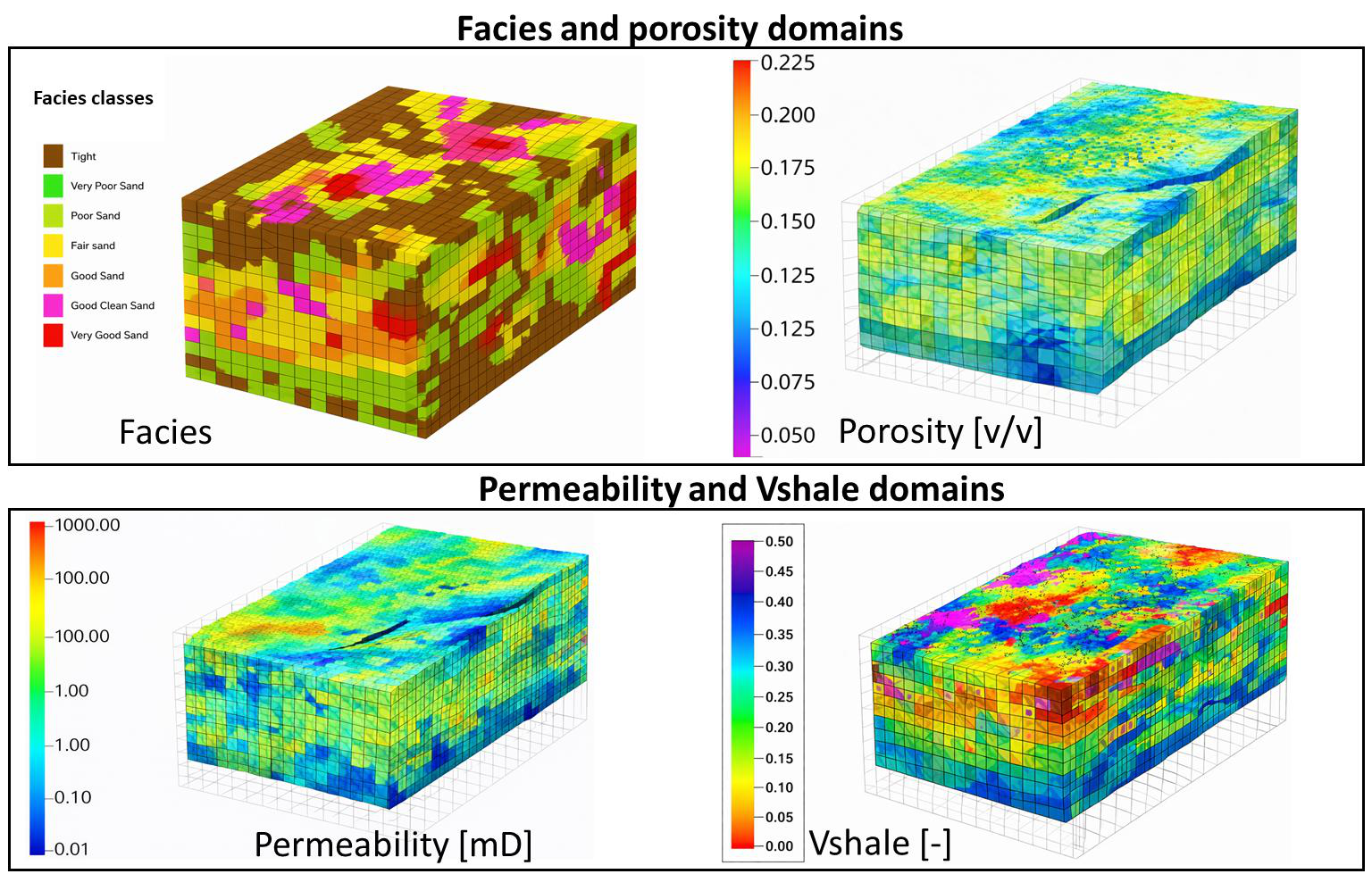
Fig 1: Representative 3D facies and petrophysical-property domains from the reference reservoir model. The
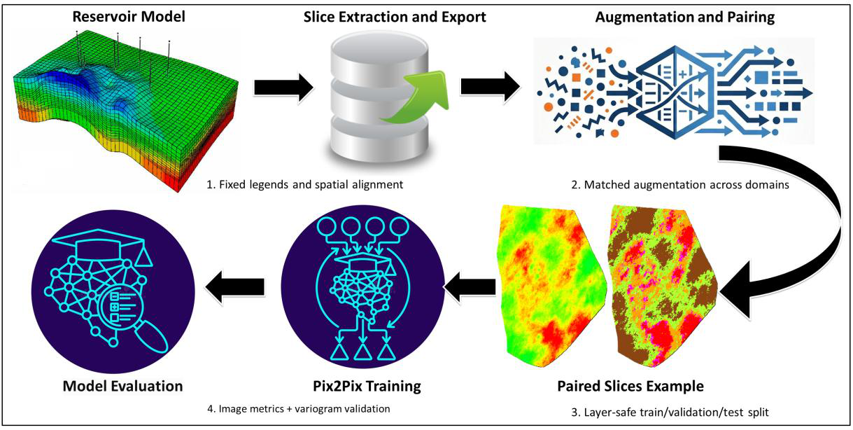
Fig 2: Dataset generation and utilization workflow for the extended Pix2Geomodel implementation. Reservoir
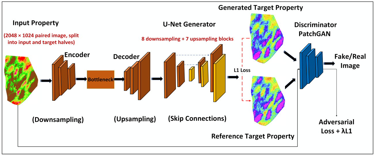
Fig 3: Pix2Pix architecture used in the current Pix2Geomodel extension. The framework uses a U-Net generator
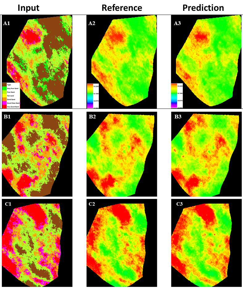
Fig 4: Facies-to-porosity translation for three representative test cases. Each row compares the input facies slice,
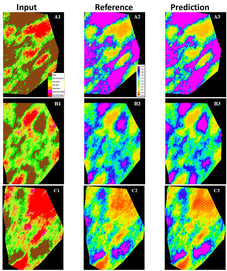
Fig 5: Facies-to-VCL translation for three representative test cases. Each row compares the input facies slice, the
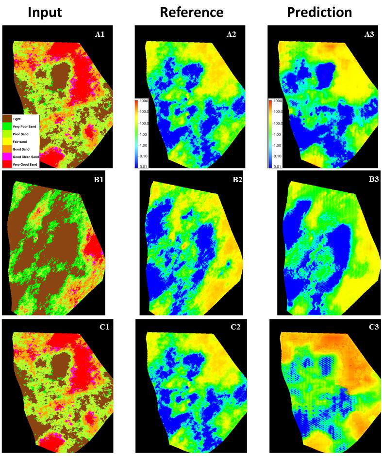
Fig 6: Facies-to-permeability translation for three representative test cases. Each row compares the input facies
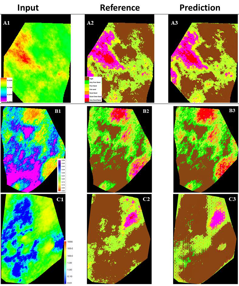
Fig 7: Inverse property-to-facies translation for representative test cases. From top to bottom, A1–A3 show
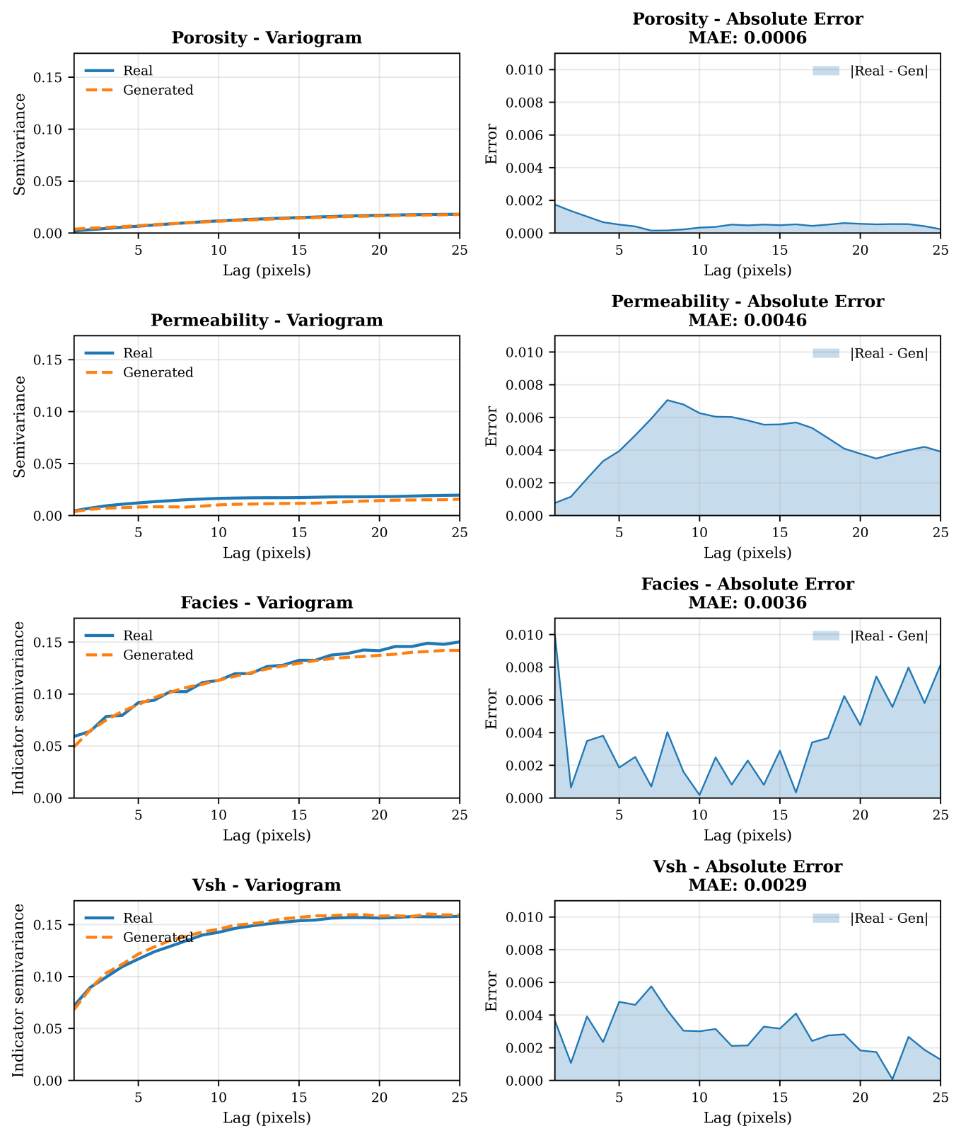
Fig 8: Spatial-continuity validation of the generated outputs. Experimental variograms for porosity, permeability,
Limitations
- Dataset limited to a single proprietary reservoir model with relatively sparse vertical sampling (54 layers), limiting generalization to other reservoirs or 3D volumetric data.
- Evaluation metrics focus mainly on image-space similarity and spatial continuity but do not quantify errors in true petrophysical numeric values or reservoir flow properties.
- Permeability translation tasks exhibited weaker results due to complex pore-level controls not fully captured by 2D image-to-image translation framework.
- The method relies on 2D slices rather than fully 3D volumetric learning, which may limit capturing vertical heterogeneity and spatial correlations.
- Training employed fixed hyperparameters and did not explore alternative architectures or loss functions that might improve local feature sharpness or boundary delineation.
- No adversarial robustness or domain adaptation tests under distribution shifts beyond the studied reservoir dataset.
Open questions / follow-ons
- How can the framework be extended to handle fully 3D volumetric reservoir data to better capture vertical continuity and heterogeneity?
- Can more advanced architectures (e.g., attention mechanisms, diffusion models) improve local feature sharpness and permeability prediction performance?
- What is the impact of integrating physics-based constraints or flow simulations to refine facies–property translation accuracy?
- How robust is the model to domain shifts across different reservoir types or out-of-distribution geological settings?
Why it matters for bot defense
Although this study is focused on reservoir geomodeling, its core contributions in bidirectional image-to-image translation using conditional GANs under limited and heterogeneous data are relevant to bot-defense practitioners using generative models for pattern translation tasks. The paper highlights the importance of consistent paired data augmentation to enlarge small datasets, architectural choices like U-Net with PatchGAN to preserve spatial detail, and combined evaluation metrics that transcend simple pixel accuracy toward spatial continuity—a principle that could inform CAPTCHA challenge generation and bot behavior modeling. Moreover, the variability in performance across different 'properties' reflects the need for domain-specific feature understanding when applying generative models in adversarial or noisy environments. Finally, this work underscores challenges in translating between heterogeneous domains with complex nonlinear relationships, relevant when crafting or defending against automated solutions that attempt to mimic or infer CAPTCHA or bot challenge features.
Cite
@article{arxiv2605_03919,
  title={ Robustness and Transferability of Pix2Geomodel for Bidirectional Facies Property Translation in a Complex Reservoir },
  author={ Abdulrahman Al-Fakih and Nabil Sariah and Ardiansyah Koeshidayatullah and Sherif Hanafy and SanLinn I. Kaka },
  journal={arXiv preprint arXiv:2605.03919},
  year={ 2026 },
  url={https://arxiv.org/abs/2605.03919}
}